The United States Army Corps of Engineers (USACE) reports that water levels in the Great Lakes continue to rise. Lake Michigan-Lake Huron water levels rose four-inches in the last month, and are now at 580.71-feet, or 3.21-feet above chart datum level (577.5). This is a difference from the long term average level for July of plus 17-inches but the lakes are still 15-inches below the highest all-time July levels recorded in 1986. The all-time highest water in Lake Michigan-Lake Huron was recorded in October 1986; water level was almost five-feet above chart datum.
On a personal note, recently strong easterly winds overnight caused a rise in water level in Grand Traverse Bay near Northport that was, along with wave action, sufficient to set my kayak afloat from its position on the beach about eight-feet inshore beyond the usual water line. Fortunately the kayak under autonomous piloting only made it about 50-feet down the beach before it stranded in the surfline. That was a precursor to a big storm several nights later that put very larges waves ashore, which, in conjunction with the rising lake level, swept a number of low-lying docks off their supports and set them adrift. The storm also caused several small boats to drag their moorings and wreck on the shoreline.
The USACE is forecasting continued rising levels through August-September.
Great Lakes Water Levels Continue Rise
Re: Great Lakes Water Levels Continue Rise
Here are the forecasted levels from USACE for Lake Michigan-Lake Huron:
Note that if the lake level trends toward the upper bound of the forecast, by December 2017 the lake level will be at just more than 3-feet above chart datum. Compare with the all-time record low water for December, which occurred in 2012-2013, a short five years ago. Then lake levels were 1-foot 4-inches below chart datum. If the forecasted high water occurs in December 2017 it would be a rise in lake level of about 4-feet 4-inches compared to 2012. Considering the total surface area of Lake Michigan-Lake Huron, a rise in level of more than 4-feet represents an enormous volume of water added to the lake basin.
- USACE_WaterLevelChart.jpg (85.02 KiB) Viewed 4074 times
Note that if the lake level trends toward the upper bound of the forecast, by December 2017 the lake level will be at just more than 3-feet above chart datum. Compare with the all-time record low water for December, which occurred in 2012-2013, a short five years ago. Then lake levels were 1-foot 4-inches below chart datum. If the forecasted high water occurs in December 2017 it would be a rise in lake level of about 4-feet 4-inches compared to 2012. Considering the total surface area of Lake Michigan-Lake Huron, a rise in level of more than 4-feet represents an enormous volume of water added to the lake basin.
Re: Great Lakes Water Levels Continue Rise
The water level of Lake Michigan-Lake Huron continues to maintain about 1.5-feet higher than the long-term average, as documented in the United States Army Corps of Engineers (USACE) graph below:
Generally lake levels decline over winter to a minimum in February, but this winter lake levels began rising in January and increased about 2-inches by March. Lake levels in summer could be 4 to 5-inches higher than last summer's high water.
The USACE also commented:
- USACE Water Levels for Michigan-Huron
- MBOGLWL-mich_hrn.jpg (64.93 KiB) Viewed 3777 times
Generally lake levels decline over winter to a minimum in February, but this winter lake levels began rising in January and increased about 2-inches by March. Lake levels in summer could be 4 to 5-inches higher than last summer's high water.
The USACE also commented:
- All of the lakes were above their long-term average water levels for the month of March. Lake Superior declined about 2 inches from February to March. Lakes Michigan-Huron and Ontario rose about an inch, while Lake Erie climbed approximately 10 inches. Lakes Superior, Michigan-Huron, and Erie were 6 to 9 inches above their March 2017 levels, but Lake Ontario was 3 inches below last March’s level.
Re: Great Lakes Water Levels Continue Rise
Several news organizations have been carrying an article with a headline like this one:
Source: http://www.mlive.com/news/muskegon/index.ssf/2018/04/record_high_water_levels_delay.html
As you can see in the USACE data above, there is nothing about the present Lake Michigan water level that is a record setting level.
The article I mention above also cites the nature of the present high water level as being some sort of "historically high" level, when it quotes a politician, Grand Haven City Manager Pat McGuinness:
The USACE has been attempting to make repairs to the pier foundation that would typically be exposed during the winter, but as noted above, the lake level has not cooperated. However, the present level of Lake Michigan at this time of year is not close to being a record for highest level. The level is actually more than one-foot lower than the record high-water level for this time of year.
An article on a television broadcast station website cited the water level as "near-record." Apparently when a water level is more than one-foot away from setting a record, that is known as "near-record."
The news website USNEWS also calls the water levels "record high water levels," in an article they reprint from the Associated Press.
Apparently not much fact-checking is done at these "news" sites. A simple check with the USACE reports would show that while the level of Lake Michigan is a few inches higher than expected, it is not at any sort of record level. Injection of terms like "record level" or "historically high" into articles which describe climate and its effect on man are quite inappropriately used in this case.
Regarding the interference with the work to be done, the USACE notes that the water level of Lake Michigan only rose 1-inch in the month. If the success of the USACE work on the pier was contingent on the water level not rising as much as 1-inch, then a more appropriate headline would have been:
In some of the articles, the effect of the wake of passing boats is also cited as causing significant slowdown in work. One would also anticipate that the presence of wind waves on the lake that come into the entrance channel would also affect work progress. Since boat wakes and wind waves could easily be more than 1-foot in height, a rise of 1-inch in the lake level seems like it would have less effect than these other variations in water level at the pier foundation.
The wave action found in an inlet from Lake Michigan during typical winter weather is shown in the image below:
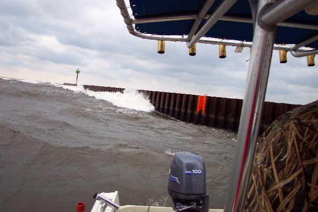
See an old CETACEA article for more views of an inlet on Lake Michigan during winter weather.
http://continuouswave.com/whaler/cetacea/cetaceaPage27.html
- Record high water levels delay Grand Haven South Pier repair work
Ongoing upgrades to Grand Haven's South Pier have been delayed for the second time in two years due to record high water levels.
Source: http://www.mlive.com/news/muskegon/index.ssf/2018/04/record_high_water_levels_delay.html
As you can see in the USACE data above, there is nothing about the present Lake Michigan water level that is a record setting level.
The article I mention above also cites the nature of the present high water level as being some sort of "historically high" level, when it quotes a politician, Grand Haven City Manager Pat McGuinness:
"We had planned to do all of the work in one year, but this water has been historically high."
The USACE has been attempting to make repairs to the pier foundation that would typically be exposed during the winter, but as noted above, the lake level has not cooperated. However, the present level of Lake Michigan at this time of year is not close to being a record for highest level. The level is actually more than one-foot lower than the record high-water level for this time of year.
An article on a television broadcast station website cited the water level as "near-record." Apparently when a water level is more than one-foot away from setting a record, that is known as "near-record."
The news website USNEWS also calls the water levels "record high water levels," in an article they reprint from the Associated Press.
Apparently not much fact-checking is done at these "news" sites. A simple check with the USACE reports would show that while the level of Lake Michigan is a few inches higher than expected, it is not at any sort of record level. Injection of terms like "record level" or "historically high" into articles which describe climate and its effect on man are quite inappropriately used in this case.
Regarding the interference with the work to be done, the USACE notes that the water level of Lake Michigan only rose 1-inch in the month. If the success of the USACE work on the pier was contingent on the water level not rising as much as 1-inch, then a more appropriate headline would have been:
- Rise in Lake Michgan Water Level of 1-inch stops USACE project
In some of the articles, the effect of the wake of passing boats is also cited as causing significant slowdown in work. One would also anticipate that the presence of wind waves on the lake that come into the entrance channel would also affect work progress. Since boat wakes and wind waves could easily be more than 1-foot in height, a rise of 1-inch in the lake level seems like it would have less effect than these other variations in water level at the pier foundation.
The wave action found in an inlet from Lake Michigan during typical winter weather is shown in the image below:
See an old CETACEA article for more views of an inlet on Lake Michigan during winter weather.
http://continuouswave.com/whaler/cetacea/cetaceaPage27.html
Re: Great Lakes Water Levels Continue Rise
Below is a graph of the water level for Lake Michigan from 1860 to 2018, a period of 158-years. I think this time range is perhaps the limit of reliable data available. The data and the graph come from the "Dashboard" project at
https://www.glerl.noaa.gov//data/dashboard/GLWLD.html
The "dashboard" is an on-line tool for accessing lake level data and graphing it. I had to reduce the size and crop the graphic to fit here. The X-axis starts at 1860 and ends at 2018. The Y-axis is in feet above mean sea level. The cyan line plots the "Master Gauge Monthly Average" water level recorded in the data.
Notable in this presentation of data is the rather much higher average water levels occurring in the 1800's. Generally when NOAA or USACE present water level data, they seem to limit the notion of "record setting" levels to a more modern era, usually only post 1918, called "the period of record." The plot above shows data from as long ago as 158-years in the past. That data shows that the present lake levels in 2018 are by no means record setting.
The only recent period of record-setting water level is actually in 2012, when the winter lake levels set records for LOW water. On this basis it seems particularly misleading for the many news reports mentioned above to be talking about "record high water" or "historically high water" levels.
The TOPIC of this thread is completely appropriate with the data: the level of the Great Lakes has been rising in recent years--rising from record-low levels. But there is no reasonable interpretation of the data that could allow one to say that the present levels are "record high" or "historically high" levels, particularly in regard to Lake Michigan.
https://www.glerl.noaa.gov//data/dashboard/GLWLD.html
The "dashboard" is an on-line tool for accessing lake level data and graphing it. I had to reduce the size and crop the graphic to fit here. The X-axis starts at 1860 and ends at 2018. The Y-axis is in feet above mean sea level. The cyan line plots the "Master Gauge Monthly Average" water level recorded in the data.
- Lake Michigan average water level per month since 1860 to 2018, a span of 158-years. The most recent data is plotted as dark blue lines; the earlier data as a cyan line. Chart datum is 577.5-feet.
- lakeMichiganHistoricalLevelsCrop.jpg (68.84 KiB) Viewed 3571 times
Notable in this presentation of data is the rather much higher average water levels occurring in the 1800's. Generally when NOAA or USACE present water level data, they seem to limit the notion of "record setting" levels to a more modern era, usually only post 1918, called "the period of record." The plot above shows data from as long ago as 158-years in the past. That data shows that the present lake levels in 2018 are by no means record setting.
The only recent period of record-setting water level is actually in 2012, when the winter lake levels set records for LOW water. On this basis it seems particularly misleading for the many news reports mentioned above to be talking about "record high water" or "historically high water" levels.
The TOPIC of this thread is completely appropriate with the data: the level of the Great Lakes has been rising in recent years--rising from record-low levels. But there is no reasonable interpretation of the data that could allow one to say that the present levels are "record high" or "historically high" levels, particularly in regard to Lake Michigan.