The Abel Buell Map of the United States

A conversation among Whalers
jimh
Posts: 11710
Joined: Fri Oct 09, 2015 12:25 pm
Location: Michigan, Lower Peninsula
Contact:

The Abel Buell Map of the United States

Postby jimh » Thu Oct 31, 2019 11:57 am

Recently I had the marvelous opportunity to visit the Library of Congress. On exhibit was an extremely well-preserved Abel Buell map of the United State published in 1784, or 235-years ago. The map is described by the Library of Congress as follows:

Abel Buell's New and Correct Map of the United States, 1784

This landmark map of extraordinary significance to the historical record of the United States was published by Abel Buell in 1784. Notably, this is the first map of the newly independent United States compiled, printed, and published in America by an American. Additionally, it is also the first map to be copyrighted in the United States. Only seven copies are known to exist and survive in major institutions in the United States, the United Kingdom, and Spain. The copy on display is considered to be the best preserved of all extant editions and was officially deposited with the Library by Mr. David Rubenstein in January 2010.


I took three photographs of the map, concentrating on the Great Lakes and their depiction in 1784. I'd like to share these images and my comments about them.

First, here is a view of the lower peninsula of Michigan with the surrounding Lake Michigan and Lake Huron:

michiganLowerPeninsulaAbelBuellMap.jpg
Fig. 1. The lower peninsula of Michigan and surrounding Great Lakes as shown on the Abel Buell map of 1784.
michiganLowerPeninsulaAbelBuellMap.jpg (151.92 KiB) Viewed 4748 times


The western lakeshore portion of the lower peninsula is described as an "Extensive Sandy Desart"[sic]. There are extensive lakeshore sand dunes on that coastline.

The present Saginaw Bay is denoted as "Saguitiam Bay", perhaps more reflective of an Indian language pronunciation.

The central portion of the state is denoted as "A Plain 150-miles," which is still a good description of that area.

Manitoulin Island, part of Canada, is well defined and called "Manitoualin Isle."

On the left edge of the map (as seen in Figure 1) there is a notation of "Grand Travers", but it seems to be more associated with what we today call Green Bay, and not with the present-day Grand Traverse bay in northwest lower Michigan. There is a depiction of an unidentified bay which we can infer was Grand Traverse bay, but the orientation is off by 90-degrees. The actual bay runs North-South for 33-miles, not East-West as seen on the Abel Buell map. (I assume "Travers" is from a French origin; "travers" may mean "breadth" or a distance across, so "grand travers" would mean great breadth or great distance across.)

A fort is denoted on the map in the straits between Lake Michigan and Huron, and the area is called "Michillimacknac." Today we call that area the Straits of Mackinac.

Detroit was founded in 1701, and is prominent. A small circle and an icon of a building marks its location, although the city name seems to have landed in Canada instead of Michigan.

Native tribes of Indians and their regions are identified as Chipeways, Ottawas, Uttawas, Wymdots, and a location called Pontowatami Town is shown at the extreme lower left. (These are likely older spellings for Chippewa, Ottawa (Outaouais in French), Wyandot or Huron, and Potowatami tribes, and Chippewa now deprecated in favor of Ojibwa.)

Now we look at the Lake Superior region.

lakeSuperiorAbelBuellMap.jpg
Fig. 2. Lake Superior and surrounding lands from Abel Buell map of 1784.
lakeSuperiorAbelBuellMap.jpg (148.93 KiB) Viewed 4739 times


Isle Royale is nicely depicted, but perhaps wider than it actually is, and called "Isle Royal." The trailing "e" must have been added by later map makers.

A second large island called "Isle Phillipoux" is also shown, but as we now know, there is no such land interposed between the Keweenaw Peninsula and Isle Royale. Perhaps "Isle Phillipoux" was just the result of confusion about Isle Royale.

The Apostle Islands are shown--all thirteen of them.

Most interesting is a notation on the land west from the Keweenaw Peninsula that mentions "about here is Plenty Virgin Copper."

The map details more than two dozen rivers in the upper peninsula that drain into Lake Superior.

An archipelago of seven islands in eastern Lake Superior is noted as "Ponchartrain I." This is likely a confusion of today's Caribou Island and Michipicoten Island.

Along the north shore of Superior several large islands are shown on the Abel Buell map. These are drawn out proportion to their modern representation.

Overall, the Abel Buell map has filled Lake Superior with too many large islands. As we know today, Lake Superior is mostly a vast open lake.

Finally, we look at Lake Huron and Georgian Bay.

lakeHuron.jpg
Fig. 3. Lake Huron and Georgian Bay.
lakeHuron.jpg (146.94 KiB) Viewed 4733 times


Notably missing is the identification of Georgian Bay, which geographers must have added later. The Bruce Peninsula is not identified but is nicely depicted. The chain of island from Tobermory over to the southeast shore of Manitoulin is also well drawn. Fitzwilliam Island is probably represented as the largest in that chain. The east shore of the deep inlet known as South Baymouth is depicted as an island.

Today's Nottawasaga Bay is called "St. Joseph." I don't see any modern map use of St. Joseph in that region, but there is a Christian Island on modern charts.

The original Abel Buell map that was on display was presented in rather subdued lighting, most likely to prevent any further decay to the map inks. The mapmaker, Abel Buell, was quite a colorful character. A wikipedia page gives some further details into his history as a map maker:

https://en.wikipedia.org/wiki/Abel_Buell
hauptjm
Posts: 45
Joined: Mon Oct 19, 2015 3:26 pm
Location: New Orleans

Re: The Abel Buell Map of the United States

Postby hauptjm » Thu Oct 31, 2019 12:31 pm

I love looking at old maps. Here is the link to view the entire map on the ArcGIS viewer:

https://www.arcgis.com/home/webmap/viewer.html?webmap=1892c872d14c4407957046b368b878ec

In my location, what is interesting is the dimensional errors of Lake Pontchartrain. It is larger in area than Mobile Bay, but appears considerably smaller than Mobile Bay.

jimh
Posts: 11710
Joined: Fri Oct 09, 2015 12:25 pm
Location: Michigan, Lower Peninsula
Contact:

Re: The Abel Buell Map of the United States

Postby jimh » Thu Oct 31, 2019 1:20 pm

Many thanks for that great pointer to a very high-resolution image of the complete Abel Buell map.

jimh
Posts: 11710
Joined: Fri Oct 09, 2015 12:25 pm
Location: Michigan, Lower Peninsula
Contact:

Re: The Abel Buell Map of the United States

Postby jimh » Thu Oct 31, 2019 3:39 pm

Regarding this map and how the Library of Congress came to have it on exhibition, there is a very good description given in the publication THE NEW ENGLAND QUARTERLY (Vol. 86, No. 3, pp. 357-397, September 2013) in an article by Paul E. Cohen, a noted author and dealer in rare maps. (If you register with the JSTOR organization at https://www.jstor.org you can read the entire 41-page article.)

To summarize, the map was offered for sale at an auction at Christie's auction house in New York City in December, 2010. It had been 95 years since another Buell map had been on the open market, and the sale was highly anticipated and well publicized. The map sold at auction for $2,098,500 (inclusive of buyer's premium), reported to be the highest price ever paid for a map at an auction. The buyer was David M. Rubenstein, a philanthropist who lives in Washington, D.C. and who has a long association with the Library of Congress. Mr. Rubenstein then loaned his purchase to the Library of Congress.

The Library of Congress themselves had participated in the December 2010 auction to buy the Buell map, but had been unsuccessful in their bidding. (Quite by coincidence, John R. Hébert--the head of the Library of Congress geography and map division who was trying to buy the Buell map--and I share the same last name.)

In 2011 the Library of Congress indicated the Buell map would be coming to the library and would be on exhibit for public viewing for five years.

I don't know the date when the map went on public exhibition, nor do I know the plans for ending the exhibition. It was just by chance that I happened to visit the Library of Congress while the map was on exhibit.

User avatar
Don McIntyre - MI
Posts: 126
Joined: Fri Oct 09, 2015 4:33 pm

Re: The Abel Buell Map of the United States

Postby Don McIntyre - MI » Tue Nov 05, 2019 3:47 pm

What I find intriguing is the small islands at the extreme southern end of Lake Huron.

jimh
Posts: 11710
Joined: Fri Oct 09, 2015 12:25 pm
Location: Michigan, Lower Peninsula
Contact:

Re: The Abel Buell Map of the United States

Postby jimh » Tue Nov 05, 2019 4:34 pm

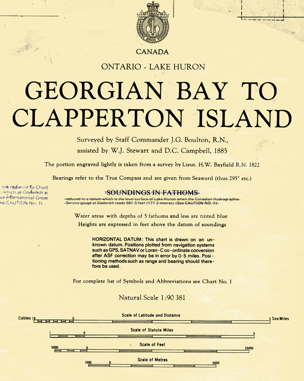
Yes, those islands are curious. I don't think there are even any big shoals in that part of Lake Huron. The Great Lakes did not really become well charted until the 1850's. I still get a laugh from my old printed copy of Canadian chart 2286 that refers to the soundings dating from 1822. Those areas were finally re-surveyed c.2000 and a new chart issued c.2008.

Image
Fig. 4. Title block of Canadian Chart 2286 mentioning portions of the chart soundings date from 1822.

Buckda
Posts: 28
Joined: Fri Oct 09, 2015 1:45 pm
Location: Michigan's Upper Peninsula

Re: The Abel Buell Map of the United States

Postby Buckda » Wed Dec 04, 2019 7:54 pm

I find it also interesting what Abel Buell chose to include and leave off in his map. For instance, Sault Ste Marie, Michigan (and Canada) were clearly already an important point of commerce in the fur trade at this point. Sault Ste Marie Michigan was founded in 1668. And the indigenous peoples of the area had been using the falls of the Saint Mary's river as an important trading post for approximately 11,000 years or more before that. As a critical (and the only) entry point for Lake Superior, which he clearly spent time to illustrate, it seems lacking.

I do think we have very accurate maps today - but it makes you wonder how much is missing from modern maps?!