continuousWave--> Sail-Logs --> Georgian Bay 2001 --> Day Three
More fun awaits us as we continue northward along the
beautiful shoreline of Georgian Bay.
(Ten Photographs)
Day Three
| Date: | Monday July 30, 2001 |
| Weather: | Fair. Sunny but hazy |
| Winds: | SE 10 |
| Waves: | Less than 1 foot in open lake |
| Departure: | Kilbear Marina Marina, Parry Sound |
| Destination: | St. Amant's Marina, Britt |
| Distance: | 55 miles by Small Craft Route |
The morning finds us slowly awakening to a warm summer day
with hazy skies. I brew some coffee
on the dock and enjoy a cup sitting on our deck chair on the
low floating dock. For breakfast Chris and I have just a bowl of cereal
and some milk. Our cruising mates head over to the marina restaurant
for some heartier chow.
I check the weather forecast on the marine radio:
	For Georgian Bay:
	Winds southeast 10 knots increasing to 15 knots tonight.
	Chance of showers.
	Outlook: light to moderate Southeasterlies. Fair.

	Water levels for 24 July:
	Lake Superior 0.18 meter ABOVE datum
	Lake Huron 0.03 meter ABOVE datum.
The marina bathrooms are a long walk up the pier. With precise
coordination we all manage to get in for a shower. The three
shower rooms are small but there is good water pressure and plenty
of hot water.
The marina has a very nice store that has a broad inventory of
marine supplies and spares. They also have a big travel lift and
haul out. At this moment the lift is occupied with a beamy 40-foot
trawler from Toronto that is resting in the slings above the yard. One of
the trawler's twin rudders is bent, the result of backing into
a rock in some shallow water. Her owner and family are staying aboard,
living on the boat while it's on the hard and the repairs are made.
Fueling
We've been talking about getting underway earlier, so we've set
a target of 10:00 a.m. Around that time I get my engines started
and head for the fuel dock. Larry recommends topping off the tanks
here as fuel is likely to be more expensive as we proceed north.
This morning I take on a surprising amount of gasoline,
needing 100 liters or 26 gallons to get the fuel gauge reading "F" again.
My knot-log indicates 64 statute miles travelled, making my fuel economy about 2.5 MPG.
Fuel is $0.84/liter (Canadian dollars), or about $2.08/gallon (US dollars).
I also top off the oil reservoir tanks, each engine needing about
a quart and a half to reach full again. I am adding the "premium" brand
2-cycle engine oil, the Mercury labeled TCW-III oil that costs $18/gallon.
So I've burned about $13.50 in oil, $55.50 in gasoline, making my cost
for this leg $69, or roughly a dollar per mile.
The engines are oil-injection and use "precision blend", a Yamaha
name for oiling that is adjusted for engine speed. The engines seem
to be very lightly oiled at idle, as they produce little smoke.
I am curious what the overall ratio will work out to be.
We have run through about 26 gallons of gas while only using 3 quarts of oil,
a ratio of (26 X 4) : 3 or about 35:1. This is not as high as I expected.
Perhaps, like the gas tank, I had not filled the oil reservoirs to the brim
at the start.
We pay for the dockage and fuel, also adding a couple of bags of ice to the bill and the
coolers, then clear the gas dock to make room for our other boats. Surprisingly,
it takes only about 120 liters to top off the tank in WHALE LURE,
her twin 200-HP engines having not used much more fuel than my smaller two.
And Larry has made two extra runs in his boat that I didn't cover,
so WHALE LURE's fuel economy is surprisingly good.
By the time everyone is finished at the gas dock and back underway,
it is past 11:00 a.m. as we head out of the marina entrance channel,
a short stretch marked by paired red/green buoys that leads to
St. Aubyn Bay and the Small Craft Route.
![[Photo: Whalers passing through Canoe Channel.]](images/3JIMGCanoeChannel545x362.jpeg) |
Canoe Channel
Just north of Parry Sound we take a shortcut out to the main channel.
The Canadian flag flies as a courtesy ensign from Jim's bow rail,
a reminder we are cruising abroad. As we go north, signs of
development like that telephone pole on the shore will disappear.
Photo Credit: Jim Gibson
|
![[Photo: Whaler 20-Revenge in front of lighthouse at Snug Harbour.]](images/3LHGLighthousePAB641x344.jpeg) |
ContinuousWave
Snug Harbour lighthouse in the background,
and continuousWave in the foreground makes a nice
picture of Georgian Bay boating. Even though it is mid-summer
we had our canvas up almost the whole trip. It was a much appreciated
gift from website visitors.
Photo Credit: Larry Goltz
|
On our way back toward Snug Harbour again, this time
we squeeze through the narrow Canoe Channel where the rock sides are
27 feet above the 8-foot deep water. Then we are back into our familiar
shoreline route, weaving among the buoys and daymarks just inshore of
a string of protective barrier islands. Just past noon the
Shebeshekong Channel takes us behind Franklin Island while
twin ranges guide us in and out of the tight passage at Frances Point
(Sheet 1 of Chart 2203; Mile 19)
Around Mile 23 we get a glimpse of the open lake.
The winds are light from the southeast and the waves out there are less than
half a foot in height. On the small craft route they are even smaller.
We turn into the wide protection of Shawanga Inlet
and make a beautiful seven mile straight run through the islands and rocks
of this large bay before heading more westerly inside of aptly named
Turning Island. As we proceed up Middle Channel we pause to watch a float
plane take off. Three miles ahead we stop for lunch about one o'clock at the
Ojibway Club, located on the northwest side of Ojibway Island.
(Mile 33 of Sheet 2 of Chart 2203)
![[Sign: OJIBWAY CLUB]](graphics/3OjibwayClubTrans263x201.gif)
Ojibway Club
The Ojibway Club was once the Ojibway Inn, a resort hotel constructed by
American Hamilton Davis in 1906 to provide lodging for an
clientele of guests looking for a rustic yet refined vacation
in the cool summer temperatures of Georgian Bay.
In the days before air-conditioning, it was the place to be in August.
It survivied in that capacity longer than any of its competitors,
but eventually the hotel closed, and the facility is now
run as a island club and community center, with a restaurant and store.
It is a center of activity for all the cottagers in this beautiful stretch of shoreline.
There are about eight floating finger piers emerging from the rocky island into
very deep water. We find a spot and tie up our trio of Boston Whalers.
We are greeted by a friendly college-aged young fellow whose
summer job is both dock master and store clerk at the island.
It is no problem for us to tie up for a while and visit.
Passing boats like ours are welcome to come for lunch or dinner, and to shop.
The island is the hub of a large community of cottages, and boats come
and go from the docks continuously. Much to our surprise, a very high
percentage of them are also Boston Whalers! We see a wide variety of
13-foot and 15-foot hulls, an occasional 17-footer, and even a very nicely
restored 21-Outrage. And the island residents see our larger Boston Whalers,
too. Several of them come over to chat.
Without out any prompting, we get spontaneous comments like this:
From the dockmaster: "I really like these older-hull-style Whalers.
The newer hull design is not as good. This older hull really rides nicely."
From a cottager: "My brother wanted a Whaler and he bought a new one.
He had it about three weeks and he didn't like it. Sold it and bought
a used, older style Whaler."
And from several admirers of WHALE LURE: "I didn't know they made Whalers this big!"
The surrounding islands contain hundreds of cottages, most of them held in
the same family for many generations. Young boaters arrive and depart
the docks in small outboards. It is a great place to spend your summer
as a young boy or girl.
"I feel cheated," I say, "that my great-grandfather did not leave me a place to
inherit up here. What a spot!"
"Isn't this the place," says Larry Goltz. "You could really grow up
with a Whaler around here."
From all across the States and Canada the descendents of these early land owners
return to enjoy the brief summer. We bump into a U.S. family
from Chicago, and discover the mom went to high school in our home town
of Birmingham, Michigan.
It is a small world and here a rather genteel one, too.
We take lazy lunch on the porch at the Inn, looking out through the shade of
the tall pine trees at the sun on the beautiful water
and watching the stream of boats coming up and down
the Small Craft Route just across the little bay.
The Ojibway Club restaurant serves up an excellent Grilled Chicken Club sandwich
that we enjoy on the pine shaded patio overlooking the water.
![[Photo: 25 and 20 foot Whalers at dock, Ojibway Club]](images/3LHGOjibwayClubDock586x380.jpeg) |
Ojibway Club
The floating docks at this island center are in about 30 feet
of water. This view shows the relative sizes of 25-foot and
20-foot Whaler hulls.
Photo Credit: Larry Goltz
|
About quarter to three we are back under way. Unfortunately, about two miles
down the channel Chris discovers that she was so relaxed on the porch at
Ojibway Club that she left her purse sitting there! Oops. We make a U-turn
and head back. As I mentioned, it is a rather genteel setting, so when we
arrive back about 25 minutes after we left, Chris scampers ashore and
finds her purse sitting right where she left it.
At 3:15 p.m. we are back underway, with purse aboard, and heading northward
to rendezvous with the other two boats who have been busy exploring the
Pointe au Baril Channel inland a couple of miles.
Pointe au Baril
Around Mile 35 (Continuation D of Sheet 2 of Chart 2203)
we rejoin our mates and turn toward the exit from the inland route
at Pointe au Baril. This is one of the few points along the eastern
shore where you can enter from the lake in heavy seas. To mark
this passage for the early navigators, a large barrel was placed on
a stake at the tip of the inlet, which then became know as
Pointe au Baril or "point with a barrel" in French.
Now a red-roofed Coast Guard building and lighthouse mark the point,
but a replica barrel still stands as well.
![[Photo: Barrel mounted on stake to mark channel.]](images/3PteAuBaril585x404.jpeg) |
Pte. Au Baril
Historically a barrel on a stake marked this safe inlet,
a tradition maintained even today.
|
![[Photo: Lighthouse at Pte. Au Baril.]](images/3LHGLightPteAuBaril566x374.jpeg) |
Pte. Au Baril
Coming off a stormy Georgian Bay, this is what you
are looking for to locate the deep water inlet at Pointe Au Baril.
Photo Credit: Larry Goltz
|
To transit here we must briefly expose ourselves to about 100 miles
of open water before we can make a sharp turn back toward shore and reenter
the protection of the inshore passage. Today it is a "piece of cake"
and we negotiate the RGR offshore buoy without difficulty.
Turning northeast for a brief leg, we clear Shoal Narrows.
Here, in one of the few instances where the chart and the route don't agree,
we find three or four buoys added to help us make safe passage.
![[Photo: 19-Outrage negotiating channel markers]](images/3LHGMemoryDaymark554x349.jpeg) |
Small Craft Route
MEMORY passes one of thousands of daymarks and floating
aids-to-navigation which allow transient boaters like us
to travel in this endless maze of rocks and channels.
This is Shoal Narrows just east of Nares Inlet.
Photo Credit: Larry Goltz
|
![[Photo: Whalers making 90-degree turn on the Small Craft Route.]](images/3SharpTurnNPtaBaril610x364.jpeg) |
Sharp Rocks, Sharp Turns
North of Pte. Au Baril and still following
the Small Craft Route, WHALE LURE leads us across Nares Inlet
and through a nicely marked 90-degree turn along the otherwise undeveloped
shoreline.
|
Just east of Hangdog Point we are again emerging from the route into
relatively open water at Red Buoy A68 when we encounter some opposing
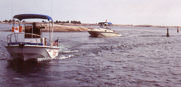
boat traffic. A rather large express cruiser, a 45-foot Sea Ray,
is about to turn into the narrow opening from the opposite direction.
Both he and WHALE LURE are making for A68 at about the same distance off.
Larry throttles back to let the big cruiser come around the floating aid ahead of him,
and I watch from ten boat lengths back with amazement as the
approaching boat cuts between WHALE LURE and the mark,
forcing Larry to hit reverse and backdown rapidly to get out of the way.
Perhaps momentarily confused by the appearance of opposing traffic,
the skipper of the other boat has incorrectly applied
the "Red-Right-Returning" rule and left A68 on his starboard side,
putting his course precisely over the 3-foot shoal that it marks.
"Hey," I say to Chris, "that guy just took that buoy on the wrong side!"
I think he must know it, too, as he goes by us without much of a wave hello,
his head down and concentrating on his chart. It is little mistakes like
this that keep all those local marina Travel-Lifts busy.
From here we go seaward toward Hangdog Reef, another spot where the
Small Craft Route ventures into open water for a sharp turn around, this one
almost a 160-degree turn at buoy A74. If there were a large sea running--and
there certainly could be--transiting Hangdog Reef would be extremely difficult.
The route threads among many rocks and shoals, and with large waves
working on your beam it would be impossible to hold to the narrow courseline
needed to make safe passage among all the hazards.
Fortunately, today there is hardly a ripple on Georgian Bay, and we can
zip out, round A74, and return to run up Hangdog Channel, guided
through the shoals and rocks by a dozen or more buoys.
North of Pointe au Baril, the number of cottages and the amount of
shore or island development noticeably declines. Our boat glides through
the water between rocky islands for the most part in their completely
natural state of pinkish granite. Bands of golden brown moss mark the limit
of the highest rise of the lake water in recent decades.
The pine trees that have taken root in the limited
soil share a distinguishing characteristic: their windward branches
are stunted and bare, while the eastward pointing limbs grow much longer.
The whole tree trunk often leans slightly east, inclined by the strong
winds that blow off the lake all winter.
The Small Craft Route now proceeds inland about two miles heading for the
village of Bayfield Inlet at the head of Alexander Passage. The Naiscoot
River drains into the lake here, creating a number of small inlets.
We turn seaward again at Gibralter Point, and enjoy a four mile
run up a natural channel with Big Burnt Island on our right and
Meneilly Island on our left.
![[Photo: Chris at helm, low rocky shore]](images/3JIMGChrisRockyPass631x357.jpeg) |
Small Craft Route
Between Pte. Au Baril and Byng Inlet, the route often
runs just inshore of a protective barrier of rocks.
Chris takes the helm for a while.
Photo Credit: Jim Gibson
|
 |
Small Craft Route
Just north of Hang Dog Reef, we wind among the rocks
and buoys. It is hard to keep track of exactly where you
are, even if paying careful attention!
Photo Credit: Larry Goltz
|
Offshore
Around 4:45 p.m. we again approach open water, and now for
the first time in our trip the Small Craft Route cannot provide us with
a passage among the rocks and shoals of the shoreline.
In many areas of the coast here the hydrographers have given up on
soundings and just marked the water with a large # meaning "foul ground."
To avoid this we must make a nine-mile passage offshore, running about
three-quarters of a mile out but only in water 8-10 feet deep. Fortunately
there is no sea running at all, and as we cruise on plane over the calm water
we can see a frightening array of huge bolders beneath us,
in some spots only five or six feet below.
We proceed northward at about 22 MPH, the speed where our boat and motors
seem most at ease. At this throttle setting the engines are running at
3900 RPM, a point where they made a nice gentle sound, and the boat's hull
rides smoothly on plane without any hint of porpoising (the repeated bouncing
of the bow of the boat up and down in the waves).
At approximately 5:30 p.m. we are making a turn around buoy A126 (Mile 55
on Sheet 3 of Chart 2203) and heading back toward shore. A range guides
us eastward, and several sets of paired buoys help us avoid shoals.
Once inshore we negotiate some tight spots between Danny Island and
its neighbors at Mile 56, before getting into the natural channel
of Byng Inlet, our destination for our overnight stop.
Byng Inlet
The wilderness beauty of the route during the last 20 miles has been
magnificent, but now two signs appear, advertising the facilities
of competing marinas. As we motor slowly up the Magnetawan River we pass the first of
these establishments, Wright's Marina, and continue inland
toward the second, St. Amant's Marina, about another mile upstream.
Even though it has less marine facilities than its competitor,
we have chosen to stay at St. Amant's Marina because of its
location close to The Little Britt Inn, the restaurant we are planning on
visiting for dinner tonight. The Inn has some docks in front of it,
but the low water level has left them in rather shallow water, making
it difficult for us to go there except on foot.
Around 6:30 p.m. we tie up at the docks at St. Amant's, which float low
in the dark, tannin stained water of the river. Unlike the gin-clear water
of the lake, this stuff resembles iced tea.
| Marina: | St. Amant's Marina |
| Address: | Box 10 Britt, ON P0G 1A0, 705 383 2434, stamant@zeuter.com |
| Mooring: | Alongside floating dock |
| Dock height: | 2-feet, floating docks. Steep ramp from floating dock to seawall. |
| Bathroom: | 1 urinal + 2 stalls for MEN. Shared with trailer park. |
| Showers: | 3, not fancy. Need Loonies to get water going, and it never runs out. |
By staying on the northern side of the Magnetawan River we are in the village
of Britt. The better-known but smaller town of Byng Inlet lies on the opposite
shore. Neither community is a bustling metropolis. Both have
commercial docks for the purpose of accommodating small tanker ships
to receive oil and gasoline, which is then hauled out by rail and truck.
The chart shows small tank farms just up from the shore on both sides of the river.
We are at the well head of the petroleum source for the region.
By cellular telephone we arrange dinner reservations at
The Little Britt Inn. They are booked full all evening until closing
in the upstairs dining room, but they can accommodate us for dinner served in
the bar at 8:30 p.m.
As has been our pattern, we enjoy an hour or so of socializing on the
dock in our deck chairs, augmented with some adult beverages and snacks.
Our discussions always include the topic of our boats and how to improve
them, but as we become more acquainted (and have a second beer)
we expand our subject matter to include a broader range of issues.
A long but well-told story brings out a hearty laugh from all the men.
The gathering breaks up. We return to our boats to dress for dinner
and to snap on our covering canvas so we won't have
to struggle with it in the dark when we return.
It is a pleasant walk up the lightly travelled coastal highway
to the restaurant. We're hopeful that there might have been
a cancellation and we could be seated in the dinning room, but
we are not that lucky. The bar will be fine, and they have a lighter
menu there, too. We all order "Georgian Bay Shrimp", a house specialty
made from strips of whitefish in tempura batter and deep fried.
This unusual preparation of the native fish turns out to be
very good.
Today is Chris's birthday, so we raise a toast in her honor.
Excepting Larry's son (who is in his twenties), Chris is the
youngster of our group, still in her forties. Our senior member,
Larry, has recently turned 60, but seems to have more energy
than everyone. Good recreation like boating keeps you young.
| Restaurant: | The Little Brit Inn |
| Location: | Britt, Ontario |
| Website: | Yes |
| Setting: | On the waterfront. Dinning Room upstairs, bar downstairs. |
| Ambience: | In the bar: better northern bar. Dining Room: looks out on river setting; nice. |
| Cuisine: | Canadian-American with fish specialties |
| Meal: | Georgian Bay Shrimp (tempura battered deep-fried whitefish strips), cottage fries with vinegar, and cold Canadian beer |
On the walk back to the boats it is a warm and calm evening.
We are moored adjacent to the fuel dock, and the large
and still brightly illuminated GAS sign casts a strange yellowish light
onto the boats. The ramp to the floating dock from the seawall
descends at a steep angle. Its design did not anticipate such low water levels.
Stepping safely down it to the docks represents one of the greatest dangers
to be overcome in the trip so far!
We have moved northward 120 miles by boat in the last two days
and been outdoors in the sun and the breeze almost all of that time.
Getting to sleep will not be a problem this evening, even in
the bright glow of the GAS sign.
The nine-day narrative continues in Day Four.
The page has been accessed times.
Copyright © 2001 by James W. Hebert. Unauthorized reproduction prohibited!
This is a verified HTML 4.0 document served to you from continuousWave
URI: http://continuouswave.com
Last modified:
Author: James W. Hebert
This article first appeared September, 2001.