1200 Ready to leave Little Current. The weather is fair, sunny, warm, temperature about 80 F, and winds are easterly at 8-11 knots. The forecast for the next 18 hours is continued fair and calm.
1230 Hobbs time: 2714.8. Knot/Log: 016.85. We are departing Little Current.
1330 Heading west from Little Current; the wind has shifted to westerly. We miss the Wabuno Channel and have to double back about a quarter of a mile. Under 170% Genoa and Main we are making 4 knots due north in the Wabuno Channel. Glorious!
1600 We lie at anchor on the west side of Bedford Harbor about 200 yards offshore in 13 feet of water. The swimming is excellent. We rigg the Boom tent; it is a great asset in sunshine.
1800 Dinner is a barbecue off the stern rail grill: shiskabob, baked potatoes, and beer--a great dinner.
1930 A 14 foot outboard with three men onboard approachs us. Two are Indians, and the other a young White, who looks a little odd and perhaps is retarded. Bob and Lela are ashore; Chris stays below. I talk to them. At first they seem somewhat threatening, but perhaps that is my misinterpretation, born from too much city-life experience. It gives us a scare. We are glad to be in the company of two other boats nearby. A second outboard with another Indian and a White English-Canadian come over. They all seem intoxicated and bent on a little fun, perhaps at the expense of making us nervous. Maybe they are just looking for a few bucks for a fishing guide fee. The white fellow says the Indians are "pirates." Is he joking? Maybe he senses my nervousness, too.
1000 Bedford Harbor. K/L 028.0 approx. [Sailed 11.15 nm yesterday.] Anchors away!!! We hoist the main with a single reef and sail off with 100% headsail. We're doing 5 knots and heeled over so we double reef to clear Macpherson Ledge. Winds are out of the north at 15 knots. Course 287T. At the helm Jim says the boat's "well balanced".
1100 Reaching up the "North Channel of the North Channel" we hit 6.5 knots in the gusts and a steady 4 in the lulls. We are heading for the Bejamins, specifically South Benjamin Harbor.
Note: call Marinas on Channel 68 only.MAFOR 14720 14900 11600 15720.
1200 Wind hauls to NE and drops to 5-10 knots. We shake out 2nd reef and then first reef, too, as we are now beam reaching towards the FL R at Robertson's Rock. I rest my sprained ankle in the cabin; Chris works at the chart table; Bob fiddles with the rigging; Lela has the helm.
1225 K/L 038.66 [Sailed 10.66 nm so far today.]
1500 UTC MAFOR 14720 14700
Plain language: NW 15-20 diminishing to 10 tonight. Fair. Waves 1 meter or less.
The 3:30 p.m. near- shore forecast: NW 10-15 Fair 1/2 meter or less becoming
light and fair.
1230 We sail into South Benjamin and try to anchor under sail only, again, but we have the bow of the boat in 6 feet of water and I yell for the engine. We back away safely under motor. We anchor for lunch near the entrance, then we move farther in to reduce our exposure to a SW swell, although there is still a northerly wind. Good thing we move because about 1800 the wind hauls all the way to SW, and we are now just in the lee of the windbreak from the western half of the island. We would have been really exposed in our first anchorage, and, even here, we are riding a surge and thinking about moving a third time.
Next the wind shifts to the west and we are left swinging at our anchor rode pointed west, into the wind, and lying abeam to the surge coming around the point. We roll gently back and forth. A great chicken dinner. The beverage tonight is BRADOR ( a Candian Beer with 7% alcohol content)! I swim to get the circulation going in my ankle again after eating too much. Bob and I fiddle with the boat. A snap shackle has broken. The Head's light switch is swapped out with a good one from the kitchen --Opps!--galley (!)
1800 K/L 042.13 [Sailed 14.13 nm today.]
WX: NW 10-15. Fair. Waves 1 meter. North Channel forecast: NW 5-10, gusting to 15. Fair. Waves half-meter or less. SOO CG on Channel 16, moving to Channel 22A.
Notes about radiotelephone: shore party dials "O" and asks for Marine Operator; tells Marine Operator to route call via Soo Coast Guard Radio (Channel 27); gives the Marine Operator the name of the vessel to be called.K/L 060.72 at Gore Bay. [Sailed 18.59 nm today.]
Sailing SW from Benjamin Islands to Gore Bay. Wind building from the West to 20-plus knots. We beat our way at 5 knots into six foot waves with white caps. As we make Gore Bay we motorsail to be sure to clear the Bay at Gorrel Point as we cannot point quite high enough, and the waves on our bow are pushing us to leeward. The engine temperature light (and alarm) come on! We shut the engine down and sail the rest of the way. Reaching south and going with the waves we hit 8 knots under 100% jib and one-reef in the main!
At Gore Bay we provision the boat and shower with hot water (Chris spends 50 minutes in the shower!). We eat at Gordon's Lodge, which has a splendid dining room and good food. Everyone has the Whitefish dinner at $10.95. We row across the harbor to get to and from the lodge--how romantic!
1030 K/L 060.72. Departing Gore Bay. The engine is run about an hour with no over-heating. The raw water intake valve was partially shut, perhaps from vibration. We open it fully and we'll keep an eye on it.
1040 OOPS! We forgot to buy more ice. We double back to pick it up.
1100 Now departing Gore Bay. Finances at Gore Bay were as follows:
Amounts in Canadian Dollars
 Dinner       $25.00
 Tip            3.00
 Misc. Stamps   5.00
 Breakfast      3.00
 My share      21.00  (Food, water, pump out, marina fee $15)
 Ice            3.75
TOTAL         $60.75
Out in the Channel we raise 150% Genoa and full main. The wind is at 310[degrees] at 5-10 knots. We are able to sail 355T closehauled at 3-4 knots. As we gain distance northward, we raise the spinnaker, turn east, and enjoy a beautiful run, cutting south of Darch Island and north of Innes Island. We jibe the chute, wrapping it around the forestay, but recover and run east between Eagle Island and Hook Island. Then we drop the chute and head for Fox Island. Chris has the pilot info from Majorie Cahn Brazier's book. We thread our way between rocks and get into the harbor. There are already about six boats here! We drop our bow anchor in 20 feet and mark it with a float. K/L 078.45 at Fox Island. [Sailed 17.73 nm today.]
We relax this morning, swimming, exploring, and enjoying Fox Island Harbor. About noon we venture out towards Oak Bay. After leaving the narrow unmarked and rocky channel at Fox Island, we turn northward into open water.
BAM! We are aground in the middle of the channel--on an unnamed island that now, with high water, lies just below the surface! The shudder and sound of grounding are a gigantic shock. Suddenly peril and danger intrude into our little world of pleasure and relaxation. We are all at fault.
At the bow, I did not see the shoal; I was looking back at the cockpit arguing about which way to go; Chris had the chart before her and did not realize the danger the high water would produce by concealing the island; Bob at the helm not watching the depth sounder - it is a collective blame we must share. We hit so hard that one of the charts has slid under the hatch, and we can not retrieve it without taking the coaming off the dodgerboard track.
When we hit we were motoring at about 3+ knots. To get free, we try to kedge off into deep water to the east of the shoal. We set our lunch hook and main anchors. We heel the boat and use the engine in reverse. We are not having much success, but then some higher waves and winds come up, and they bounce us off the shoal.
Once we are afloat again, we have to abandon the main anchor rode. We attach a life jacket to the end of the rode and toss is overboad as we drift free. Bob picks it up in the dingy. Its a tough pull to haul it aboard the pitching dingy. We retrieve the lunch hook onboard Serenity as we slide off the shoal
Artful Dodger stands by to help us. Later, the skipper tells us that they went aground three times in one season. He calls our shoal "Phantom Rock".

Very tired and drained emotionally we retreat to Fox Island Harbor to heal our wounds. We knew there was safety in this harbor.
Later in the afternoon we borrow a mask from Go Vacations 96 and dive down to look at the damage:
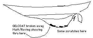
The damaged spot is about the diameter of a hand span or slightly larger. Some more damage is along the bottom edge. We are not taking on water. It appears to be surface damage to the gelcoat. We caucus about that to do about it. We will try contacting Boiles Marine in Little Current via radio. We fish for dinner. Four bass and one perch. Everyone is tired. We turn in early.
1030 Departing Fox Island Harbor. We called Boiles Marine on Ch. 68 and arranged for repairs on Friday early p.m. We spoke with Pat. We carefully motor out and turn to course 215T and proceed under motor at 5 knots until we are clear of Booth Rocks. We raise main and 150% and then the spinnaker. Chris rigs the spinnaker--almost has it, but a few little boo-boos creep in. We find them all. Up goes the chute. We are doing 5-6 knots and making our desired course without jibing. It is about 6 miles downwind to JD14 Middle Bank Fl R. Out in the clear the breeze freshens. As we approach the mark we shorten the main to one reef. The chute comes down without trouble. We harden up and lay the next mark, but then we are headed and must motor to stay safely in the channel.
1245 We head for Clapperton Harbour and anchor in 15 feet about 150 yards off shore. We row to see friends from Washington, D.C., on Go Vacations 86 --we recognize their plaid boom tent which is really a blanket! Shore explorations reveal a dense woods. Unexplained crab legs litter the beach; the remains of a party? Stew for dinner. Fishing is unproductive. A beautiful sunset. A card game. All the Brador is consumed. A call to Chris's Mom is made on the radio--collect. Everyone on the circuit is yelling. It is a long way from Clapperton Island to Birmingham!
K/L at anchor 093.94. [Sailed 15.49 nm in last two days.] Engine hours 2723.5; total running time 8.7 hours so far.
We pick up our anchor and sail out of the harbor - no engine at all! It is very quiet and serene. We glide through smooth water at 3-4 knots past the "Harbor Island Yacht Club", which is a little less exclusive than it probably was when Benson Ford was its main source of financial support.
BOAT STATUS:[The boat hangs in the slings at Boiles as the keel gelcoat repairs are made over the weekend. The crew attends a wedding in Blind River, Ontario, about 75 miles to the west on the mainland.]
1500 Departing Little Current and waiting for the bridge to open. Got boat from Boiles. He had it already back in the water. The Bill was $ 295.13 Canadian. ($ 227.00 U.S. funds). Bought: $8.00 head gunk; $45.00 groceries; $9.00 chart; $3.00 worms. Very hot weather. Wind calm.
1600 Wind dies. We are motoring on 115C / 106T toward E26/E25 at Badgely Point and then on to Snug Harbor. Fifteen boats including ours are moored in Snug Harbor tonight, but there's room enough for all. Beautiful anchorage and the clearest water we've found anywhere. Jim fishes the evening away in a "hotspot" shown him by a small towhead friend. He catches five or six in all - too bad none are keepers! Tacos and beer for dinner, a call to Jim's mom and a very pleasant evening.
North Lake Huron MAFOR
12710 19959 11730 19939 14830 11820 Waves 1- 2 meters.
Plain language: NW 15 N 20-25 Thunderstorm ending.
Near Shore Marine
Forecast, N. Channel: Small craft advisory due to wind; NW-15 becoming N 20-25;
showers ending. Wind SW10-15 at Tobermory.
A.M. The bait is taken; Jim's at it again and so is his towheaded friend. Fish for breakfast? No, not quite enough. Dinner? ...maybe. Jim catches two keepers which he fillets and we put on ice. We row across Snug Harbor and walk overland to Devils Bay Lake to try the fishing there. The fish are hungry but they're all little, at least as far as Jim can wade. After a sandwich, it's anchors away around 1 p.m.
1300 We come out of Snug Harbor heading for the Georgian Bay, but it's really gusting out here so we settle for close reaching with a single reef and the 100% jib down the Lansdowne Channel. We have a wonderful sail, rounding Badgely Island, and reaching downwind past Badgely Rocks lined up on the Lion's Rump Range; heading up again to pass between Double Islands and Ann Long Bank, we put the sails down and motor down Killarney Channel, docking at the General Store.
The General Store has a very nice produce section and a good selection of supplies. We buy a red pepper, tomato, sponges, ice cream cones, and Drambuie--all at reasonable prices too! We forgot, however, to fill our fresh water jugs--it pays to make lists! Now it is time to leave this picturesque town and head for Covered Portage Cove. We head east past the last red channel buoy and round Sheeps Island. The wind's really whipping. Wish we had a windspeed indicator. Anyway it's a good 20 knots.
There's twenty-three boats in here, and it's a little more crowded than we'd like. Jim's doing a fine job proving that even perch like muddy bottoms! We meet another Dock-4 boat (from JBM) Wind Runner--a 27 foot Catalina. He's a racer and just finished the Sarnia-Alpena. Nice guy--maybe a possibility for crewing?
2000 MAFOR Lake Huron North
13820 19830 14810 1-2 meter waves.
Plain language: N 20-25 becoming N-15. Fair.
Decoding:
13820 N at 17-21 next 9 hours. Fair
19830 N at 22-27 occasionally. Fair
14810 N at 11-16 next 12 hours. Fair
11810 N at 11-16 next 3 hours. Fair
Fishing is good. My new white Mr. Twister style got two fish in two casts. On the third cast it breaks loose from the line. The perch are hitting anything tonight; the daredevil, the flat fish, the Mepps spinner, the white spoon, the blue feathered spinner, all caught fish. More fair weather--it is cool tonight. We have dodger boards in for the first time! We have liquor on board to warm up! Tomorrow we plan to get out into some open water for some big-time sailing!
K/L 136.15 nm. [119.3 nm sailed since the start of vacation; 24.18 nm sailed since leaving Little Current on Monday.] Hobbs time 2731.0 hours. [16.2 hours of motoring since the start of vacation.] Checked engine and transmission fluid; both still over filled. Cool weather. Nice winds.
1100 Getting under way. We leave Covered Portage Cove unexplored-- we'll have to come back next year! It is cold and windy in the cove. We are both wearing heavy jackets and caps. As we motor past Ann Long Bank and raise sail the wind is fluky. Since it looks like lots of motoring today we change plans and decide to take a trip back down the Lansdowne Channel and save some distance.
1330 Browning Cove was practically empty when we got here, but as we napped it filled up. We are in the eastern end. Not much fish activity. A worm left in all afternoon was untouched at 1800! The engine runs poorly at idle and leaves unburned fuel in the exhaust. Here is our sounding of Browning Cove:

We Row by Maranantha, a very large ketch, wooden, rat lines, wooden masts.
She is rafted with a CS36, Easy Money, from GPYC.
We see a beaver swimming along the shore line.
MAFOR 11100 13900 14300 less than 1 meter waves.
Decoding: NE 0-10; N 0-10; SE 0-10 tomorrow. Fair.
The sunset was great - pink purple orange. Then a growing moon rose over Serenity. It was worthy of a picture, but the camera was not on board the dingy. Killarney air temperature 19 C (66 F).
On a range today of 295T our compass should have read:
      295 TC
    +   7  W (variation)
    = 302  MC
    -   1  E (deviation)
    =  301 CC
but it looked like 303 CC was more like it. Deviation suspect?
1000 Departing Browning Cove. K/L 149.94 nm. [13.79 nm sailed yesterday -
133.09 nm since the start of vacation.] Engine hours 2734.5. [Motored 3.5
hours yesterday and 19.7 hours since the start of vacation.]
We are motoring today. The water in Frazer Bay is calm,
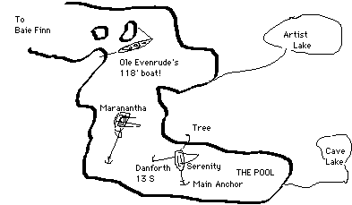
almost like glass. We are going to Baie Fine ("Bay Finn").
Our diesel fuel should be okay. We have motored about nine
hours since our fill up.
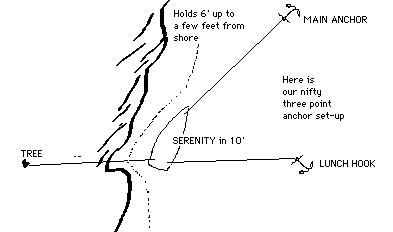
1330 We arrive at The Pool! The trip up was not as difficult as we imagined-- if you pay attention to where you are and identify each rock/island. Surprisingly enough, just past the entrance abeam the lodge the depth sounder went off like crazy and we saw below us to either side boulder-like rocks! Foraging the fjord--it's spectacular!!! Anchoring here has proven difficult. Four tries later we break for lunch hoping the anchor will settle. Despite the weedy bottom it does take, but we then proceed to clock in such dizzying fashion.
We decide these crazy winds necessitate a stern anchor, tied to shore. We let out scope on the original and cozy up to the shore. Jim rows out a third anchor, a sort of tripod to keep us off the rocks if need be.
The anchorage is truly a feast for the senses with its mountainous background. We row our dingy over to the pool end and hike the trail to Cave Lake. It's a short walk through forest primeval as it follows a meandering stream bed. Back to the boat, I to read and Jim to fish. Jim lands 1,2,3,4 . What a hotspot ! Sunfish are practically leaping out of the water to take the bait. Too bad only one and a half worms are left , and thus ends the fishing.
Maranantha is here, too. Her skipper helps us motor the long anchor rode ashore. She is a 65 foot Ta Chaio built, Perry design. She had trouble anchoring, too. Their plow would not hold, and they are using a Danforth and 200 feet of chain.
We are anchored well now. The main bow anchor is set. We have a line to shore and a second anchor to keep us off the shore if the winds change--which they seem to do every ten minutes here. At the five foot charted entrance we had 11 feet, but at the main entrance we saw enormous boulders! [We wonder if we somehow passed the buoy on the wrong side? Impossible!] It is very weedy here and everyone has trouble anchoring. Fish adopt our boat and we see a beaver swimming along the shore for the second night in a row.
FORECAST: light Southerly increasing to 10 knots tonight. Fair. Southwest at 10-15 and scattered thunderstorms tomorrow.
WILD DAY! Foul anchor trip line on prop. Over the side to fix it. Very heavy weather at Frazer Bay. Cooling alarm. Sail into Browning Cove. Set anchor. Breaks out, twice. Raise sail; sail back. Started engine. Okay temperature after 30 seconds.
Copyright © 1996 by James W. Hebert. All rights reserved.
Page Last modified: 6/8/96
URL:http://continuousWave.com/sail-logs/nc1987/index.html
JWH