search | FAQ |
profile | register | author help
|
|
|
| Author | Topic: Satellite Weather Radar |
| jimh |
 posted 08-06-2008 09:25 AM ET (US)
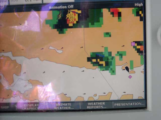
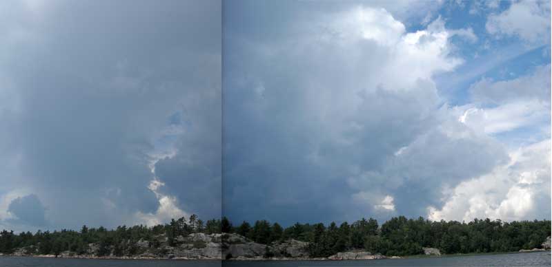
 On Friday last we were at anchor in a well-protected inlet on the north shoreline of Lake Huron just east of Wicksteed Point, a place called BEARDROP HARBOUR. The name comes from the occurrence of a medium to dark brown moss that grows in clumps in the rock crevices and resembles bear scat. The atmosphere was unsettled and a system of thunderstorm cells was blowing in from the west. From our vantage point they appeared to be passing just north of us. My meteorological theory was that the heat of the land offered them more energy than the cool water of Lake Huron, and that, along with the onshore breeze of 15-knots, was directing the storm cells inland. We could see them visually with great clarity. We were a raft of seven boats lying at anchor, and as it happened one of the boats, VINGILOT, was equipped with a multi-function display and a satellite receiver that subscribed to a weather radar service, and this combination allowed us to see the storm system electronically, as well as to see some vectors indicating the likely winds and path of the storm. I took three images of the storm, one of its electronic display and two of its visual display (which I have combined into a panoramic view). Here is the storm cell on RADAR:
As we hoped, it passed just north of us. As soon as it did, we hauled anchor and headed for the marina. |
| leapinlunker |
posted 08-07-2008 08:17 AM ET (US)
The system as depicted in Jim's post consists of Raymarine's C-80 Multifunction display connected to Raymarine's SR 50 Sirius Radio Weather and Audio Module. As mentioned, a subscription is needed to access the weather and, of course, Howard Stern. Some might say that [on-board] radar effectively identifies strong weather patterns, and in fact once proficient reading radar echos one can become quite good at interpreting them. However, in certain geographic locations radar has limited capabilities and the North Channel is one of those places. This is due in part to the numerous, say hundreds, of islands and adjacent mountain ranges. Besides, radar is not always practical on smaller boats. Both Raymarine and Garmin provide weather service modules that are compatible with their multi function displays. I prefer Raymarine products for on water applications, although in my business I use exclusively Garmin. My friends that have the Garmin units believe they are more user friendly, perhaps so. I will say, and I believe all who were on the North Channel rendezvous will attest, that a satellite weather service is worth the price of admission. Terry |
| bluewaterpirate |
posted 08-07-2008 09:10 AM ET (US)
The XM/Sirius Weather functionality really adds to your situational awareness and gives you the necesaary information to make good sound decisions in regards to the safety of you, your crew, and boat. Here are some videos of a Garmin 545 with XM Weather functionality.
http://albums.phanfare.com/4892322/2159331_2324365#imageID=31001049 Garmin 376c Auto Mode with active XM Weather display http://albums.phanfare.com/4892322/2159339_2459167#imageID=31003240 http://albums.phanfare.com/4892322/2159339_2595646#imageID=38177648 Tom |
Powered by: Ultimate Bulletin Board, Freeware Version 2000
Purchase our Licensed Version- which adds many more features!
© Infopop Corporation (formerly Madrona Park, Inc.), 1998 - 2000.