![]()
Without too much fanfare, the Canadian Coast Guard has moved the range-marked and buoyed entrance channel to Beaverstone Bay. For many years Small Craft Chart 2204-Sheet 3 showed a complex series of ranges that led one on a path east and south of Toad Island. Several buoys supplemented the ranges, creating a five-leg course among countless rocks. In 1997 these range towers and marks were removed, and in their place a new buoyed approach installed, leading west and north of Toad Island and marked with seven floating aids and no ranges.
The new approach follows a much more natural passage into Beaverstone Bay. A pair of buoys (D90/D91) lead you past the shoals south of Hincks Island. The 2-foot shoal off the NE tip of Toad Island is now marked by red buoy D92/2. Other than these shallows, the channel is naturally deep and hazard free, the limiting depth being nine feet at low water datum near South Rock. You should update your Chart with these new marks. Thanks to Charlie Stevens of Guelph, Ontario for this information.
MARK     LAT        LON        (Deg/Min/Sec)
D84     45 54 35   081 12 03
D86     45 55 06   081 13 48
D88     45 56 06   081 13 48
D90     45 56 27   081 13 16
D91     45 56 32   081 13 11
D92     45 56 43   081 12 47
D92/2	45 56 55   081 12 10
The official notice is reproduced below
The new approach seems to be an improvement, considering how the old route led one to within a hair's breadth of a 2-foot shoal. Transiting that old range entrance was really quite a bit of fun, especially in a fog. You can read about one of our adventures on it from my journal of our 1992 cruise.
Once in the calm waters of Beaverstone Bay, you will find many of the islands occupied with cottages. This makes them less attractive as anchorages, as I always prefer to avoid intruding on someone else's vacation as much as possible. The eastern shore of the Bay is part of the Point Grondine Indian Reservation. At Muskrat Bay you will find an excellent anchorage, as well as a good spot to fish for Northern Pike. Behind Nobles Island is another good refuge. The waters there contain plenty of smallmouth bass, too.
To exit to the north and enter Collins Inlet, you must negotiate a dredged passage at the very top of the bay. There the channel is marked every fifty yards by paired buoys. The shallow backwater of the bay was initially dreged to a depth of six feet, but you can expect occasional shoaling. In 1992, with lake levels only 0.5 meter above datum, our 4-ft, 10-inch draft passed through without bumping. Yea!
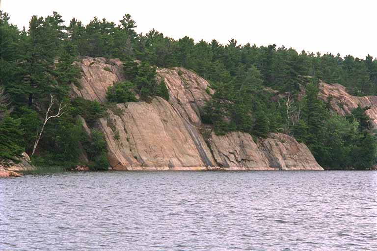
Once past this shallow spot, you turn westward again into Collins Inlet. This is a beautiful stretch of deep and clear water that will carry you 25 miles westward, back to Georgian Bay. Along the river, the shoreline consists of huge up-thrust granite rock, as this picture shows. The nearly vertical orientation of the rock strata is very evident. You can also see the lighter colored rock at the waterline, which marks a previous year's higher water level. The gorge effect of the rocky walls makes the wind abate -- unless blowing from due-west--and provides a chance for a serene trip. The depth averages over 20 feet, and navigation is rather straightforward: stay in the middle!
At the center of Collins Inlet the waters widen and form Mill Lake. Here many cottages and resorts have been built, but their impact on the beauty of the region is minimal. There aren't any floating aids, but you can safely coast down the western side of Mill Lake, all the way to the southern end. South of the small river that flows in from the west is a good anchorage, but watch out for an uncharted rock that rises in the middle of that little recess into the shoreline.
Exiting from Collins Inlet, you again encounter the full fetch of Georgian Bay. With a strong southwest wind blowing, you are in for some rough conditions. The waves seem to richocet back from the rocky shoreline to the north, producing nasty and mixed seas that will make your three-mile trip to Killarney something to remember. On one such a windy afternoon, we led a string of medium-sized power boats west from the flashing red light on Flat Rock. They were all eager to pass our slow-moving sailboat, but in the horrendous chop we encountered, not one increased their speed above our 5 knots. As we slogged to windward close-hauled, bouncing around in 6-foot waves, we were extremely glad to have avoided twenty more miles of such travel by taking the "inside" route through the river and bay. We also gained a better understanding of the advice offered by the Continuous Marine Broadcasts:
"Remember winds and waves can vary considerably
due to shoreline effects."
*707 LAKE HURON - GEORGIAN BAY - TOAD ISLAND - Buoys and beacon range.
| Charts (Last correction) - 2204(Sheet 3)(Compartment C-D)(French River to/à Beaverstone Bay) (NAD 27)(4-11,14-18) - LC 2244(NAD 27)(3-9)(131/98) - 2204(Sheet 4)(Compartment D-E) (Beaverstone Bay to/à Killarney)(NAD 27)(8-13) - LC 2245(NAD 27)(1-5,8,9)(459/97) | ||||
| 1. Delete | track line | between and |
45°57'00" N 81°11'33" W 45 56 44.5 N 81 12 01 W 45 56 30 N 81 12 13 W 45 56 10.5 N 81 12 14 W 45 56 06 N 81 12 18 W 45 56 01.5 N 81 13 02 W 45 55 10 N 81 13 59 W 45 55 05 N 81 13 48 W |
|
| 2. Add | track line | joining and |
45 55 05 N 81 13 48 W 45 55 10 N 81 13 53 W 45 56 06 N 81 13 53 W 45 56 10 N 81 13 49 W 45 56 45 N 81 12 46.2 W 45 56 52.5 N 81 12 26 W 45 57 07 N 81 11 33 W |
|
| 3. | red spar buoy, marked D88 | 45 56 06 N 81 13 48 W | ||
| 4. | red spar buoy, marked D90 | 45 56 27 N 81 13 16 W | ||
| 5. | green spar buoy, marked D91 | 45 56 32 N 81 13 11 W | ||
| 6. Delete | track line | between and |
45 57 17 N 81 11 06 W 45 56 44.5 N 81 12 01 W 45 56 30 N 81 12 13 W 45 56 10.5 N 81 12 14 W 45 56 06 N 81 12 18 W 45 56 01.5 N 81 13 02 W 45 56 10 N 81 13 59 W 45 55 05 N 81 13 48 W |
|
| 7. Add | track line | joining and |
45 55 05 N 81 13 48 W 45 55 10 N 81 13 53 W 45 56 06 N 81 13 53 W 45 56 10 N 81 13 49 W 45 56 45 N 81 12 46.2 W 45 56 52.5 N 81 12 26 W 45 57 17 N 81 11 06 W |
|
| 8. Add | red spar buoy, marked D92 | 45°56’43" N 81°12’47" W | ||
| 9. | red spar buoy, marked D92/2 | 45 56 55 N 81 12 10 W | ||
| 10. Delete | beacon range | 45 56 37 N 81 12 13 W (approx.) | ||
| 11. | port hand daybeacon | 45 56 38 N 81 12 11 W | ||
| 12. | track line | between and |
45 57 17 N 81 11 06 W 45 56 44.5 N 81 12 01 W 45 56 33.5 N 81 12 10.5 W |
|
| 13. Add | track line | joining and |
45 56 35.6 N 81 13 02.5 W 45 56 45 N 81 12 46.2 W 45 56 52.5 N 81 12 26 W 45 57 17 N 81 11 06 W |
|
| 14. Delete | beacon range | 45 56 19 N 81 12 43 W (approx.) | ||
| 15. | beacon range | 45 56 07 N 81 12 11 W (approx.) | ||
| 16. | beacon range | 45 56 23 N 81 11 59 W (approx.) | ||
| 17. Reposition | red spar buoy D88 | from to |
45 56 01 N 81 13 01 W 45 56 06 N 81 13 48 W |
|
| 18. Delete | Inset Entrance to/Entrée à Beaverstone Bay | 45 54 21 N 81 15 24 W (approx.) | ||
| NOTE: | Digital data products 2204R/M, 2244R/M, 2245R/M, 73052(2244) and 73054(2245) may also be affected. Contact Nautical Data International Inc. (NDI) or your local Value Added Remarketers (VAR) for updates. | |||
| (AMA8035-10-5-13) | (DFO-C98-166)(CCG-D98-028) | |||
![]()
![]()
![]()
![]()
![]()
![]()