For larger vessels with CLASS-A AIS carriage, their Static Ship Data is sent in AIS Message 5, which also includes voyage related data; among the data sent are:
--vessel MMSI
--vessel IMO number
--vessel CALLSIGN
--vessel NAME
--vessel type and cargo type
--vessel overall dimensions and reference point for the reported position
--type of electronic position fixing device
--ETA at destination
--maximum present static draft
--destination
Smaller vessels equipped with CLASS-B SOT DTMA or CLASS-B CS TDMA devices will send their static data in Message 24.
Details about all AIS messages are found in the USCG NavCen website: https://www.navcen.uscg.gov/?pageName=AISMessagesAStatic
The static data is only transmitted every SIX MINUTES. In order to receive this data, your AIS receiver has to have been receiving the transmission from the vessel at least as long as six minutes, and possibly more. If your receiver misses the transmission, it will take another six minutes for it to be sent again. For vessels whose AIS signals are weak and fading in and out, a receiver may miss this message data several times.
For vessels with a CLASS-B transponder, AIS Message 24 Part B Static Data Report includes similar data about ship dimensions and relative position of the GNSS sensor.)
A vessel with AIS will more frequently transmits AIS Messages giving position reports about its position and speed ("Navigation Data") compared to the intervals at which it transmits information about itself ("Static Data") The AIS Messages 1, 2, or 3 (all AIS position report messages but sent in different circumstances) are sent as often as every two seconds (when moving rapidly), at 10-second intervals (when moving more slowly), and at three minute intervals when at anchor. The position report includes the following data:
--vessel MMSI
--vessel navigation status
--vessel rate of turn
--vessel speed over ground
--accuracy of position report
--vessel latitude
--vessel longitude
--vessel course over ground
--vessel true heading
Because the static data is only sent at six minute intervals, when viewing information about an AIS target vessel such as the vessel's NAME, or its CALLSIGN, and its hull dimensions may appear be shown as blank. This is particularly true for Class-B AIS transmitting vessels, because their static data is sent in Message 24, and broken into two parts, 24A and 24B. Message 24A is sent first, and Message 24B must be sent within one minute afterward. If there is any signal fading or loss of signal, the complete message, 24A and 24B may not be received without error, resulting in another six or seven minutes elapsing before Message 24 can be received in whole and available to be viewed.
Finding that Class-B AIS target vessels to not contain some of the usual static information may also be due to improper configuration of their AIS transmitter. In the USA the AIS transmitter (by federal regulation) cannot be initially configured by the vessel owner, but instead must be preconfigured by the authorized dealer selling the device. If the dealer was not give all the necessary information that will be sent in static data Message 24, there could be omissions in the data that was programmed into the AIS device and corresponding lapses in the data that will be transmitted.
VESSEL POSITION
It is important to note that when a vessel transmits its position, it is really sending the position of the antenna of its GNSS receiver or other sensor. For large vessels that might be 1,000-feet long and 150-feet wide, the location of the position sensor is significant to know. If the vessel has its navigation house at the stern, the GNSS antenna will typically be there, too. The position reported is thus associated with the location of the GNSS antenna; the bow of a large vessel with its GNSS antenna at the stern could be 900-feet away from the reported position.
DISPLAY ON CHART PLOTTER
The technical details of the AIS system are set out in:
Recommendation ITU-R M.1371-5 (02/2014)
Technical characteristics for an automatic identification system using time division multiple access in the VHF maritime mobile frequency band
That recommendation is silent on the topic of how an AIS vessel should be displayed on a chartplotter. In general, there seems to be two methods in use:
--the target vessel is drawn at its reported position with a generic icon that does not show any ship dimensions, or
--the target vessel is drawn as a ship outline in proportion of its reported length and breadth, relative to the reported position of the GNSS sensor on the ship.
These two general types of display are shown below:
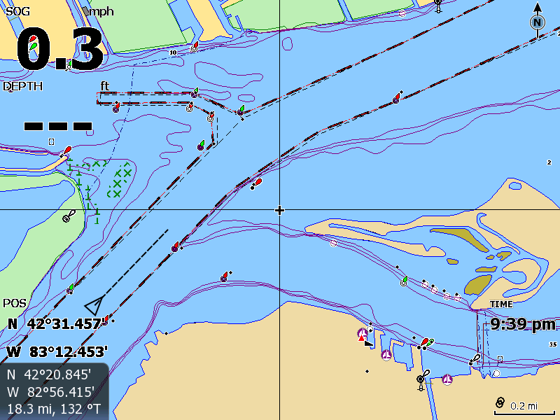
The AIS target is drawn on this chartplotter as a generic icon without any ship dimensions being represented; this screen capture is from an Lowrance HDS chart plotter.
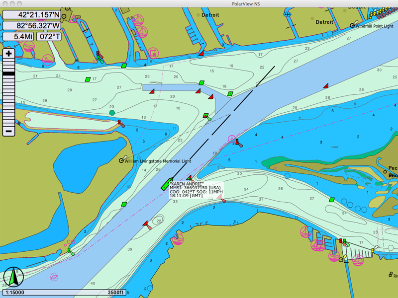
The same AIS data as a above, but drawn on an electronic chartplotter than can show the ship representation on the chart with its proportional dimensions; this screen capture is from PolarView NS, a chartplotter program that runs on a computer, rather than on dedicated marine electronic hardware.
In the above comparison, the same data was available to both chart plotters; the data was played out from a file of recorded AIS messages to each chartplotter. The difference in representation is due to differences in the chartplotter capabilities to display AIS targets.
It is important to remember that static data about the ship sent in AIS Message 5 is only transmitted at six minute intervals, and a chartplotter cannot draw the ship as a proportionally represented icon until it has received this data.