![]()
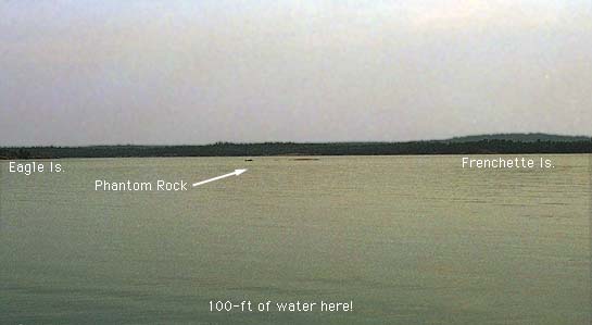
While not named on any Canadian Government Chart, Phantom Rock is well know to cruising sailors. It juts out of an otherwise clear and deep passage northwest of the Benjamin Island group. It's visible just below the horizon in the center of this picture.
This navigation hazard is charted as a small island, which has only 2 feet of elevation above chart datum, lying west from the northern tip of O'Connor Island, west of Fox Island. In most years, the summer water levels are typically 2-3 feet above datum, causing this "island" to become submerged and turning it into a very dangerous shoal.
It is located in the middle of a heavily traveled passage, and it is completely unmarked by any navigational aids or warnings. The amount of bottom paint found on the rock is testimony to the numerous groundings that occur there.
The naming of this hazzard is attributed to Howard Blossom, a Great Lakes Cruising Club member of reknown. Not coincidently, Mr. Blossom's boat is named Phantom and lent the hazzard the name it bears today. The story of the rock's discovery is an interesting one, worthy of more details.
Mr. Blossom was among the first of the modern era of recreational sailors to cruise in these waters. To locate otherwise uncharted shoals (there were many!), he employed stereographic aerial photographs, carefully studying them for indications of shoals. He spend many winters reviewing these photographs, and many summers looking for the shoals and sounding the depth of water on them. His discovery of Phantom Rock was especially pleasing, since the hazzard had been missed in earlier surveys by both the British and Canadian Services, and because Phantom Rock is located in the middle of a heavily travelled waterway.
On the overcast and completely calm day this picture was taken, Phantom Rock was making one of its rare appearances. In contrast, in the summer of 1987, it was almost four feet under water! I say "almost" because in July of that year we tried to sail over it. There's a story to go with that.
The photograph is taken from the eastern side of Phantom Rock, looking almost due west. In the background are Eagle and Frenchette Islands.
![]()
![]()
![]()
![]()
![]()
![]()
This article first appeared in 1996.
Copyright © 1996, 1997, 1998, 1999 by James W. Hebert. All rights reserved.
This is a verified HTML 4.0 document served to you from continuousWave
URI: http://continuouswave.com
Last modified:
Author: James W. Hebert