 ContinuousWave
 Whaler
 Moderated Discussion Areas
ContinuousWave: The Whaler GAM or General Area
Picked the Wrong Side of the Buoy
Moderated Discussion Areas
ContinuousWave: The Whaler GAM or General Area
Picked the Wrong Side of the Buoy


search | FAQ |
profile | register | author help
|
|
ContinuousWave Whaler Moderated Discussion Areas
ContinuousWave: The Whaler GAM or General Area
Picked the Wrong Side of the Buoy
|
| Author | Topic: Picked the Wrong Side of the Buoy |
| 6992WHALER |
 posted 08-21-2014 02:13 PM ET (US)
posted 08-21-2014 02:13 PM ET (US)  
We made a small mistake on our Georgian Bay trip last week. Caught it on the Go-pro mounted on the hard top. We coasted over some pretty shallow rocks.
We were going down Stream. What was confusing was that we had a day beacon and a buoy of the same color. I think the day beacon should have been red and mounted on the left hand shore. If the main course was on the left, mounting a red day beacon would pull you to the leftt hand shore.
|
| Buckda |
posted 08-21-2014 05:59 PM ET (US)
Sometimes, in those areas, the actual channel is so narrow, it seems impossible that the bouys are in the right place! Especially true for MC Gregor Bay, but also true for the bay of Islands. Glad you made it unscathed. I left some gelcoat on a rock in McGregor Bay a few years ago. The rock was on the chart, but there were no day marks or bouys to guide you in that area. I think that is why Stanley Boats are so popular up there! |
| 6992WHALER |
posted 08-21-2014 10:31 PM ET (US)
Dave we missed you on this trip. You should have been there to steer me right. John |
| K Albus |
posted 08-22-2014 09:53 AM ET (US)
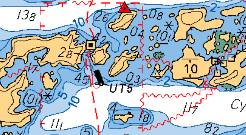
The buoy that John passed on the wrong side appears to be Buoy UT5 in the Bay of Islands, which is just north of Little Current in Lake Huron's North Channel area. John states that the buoy was not shown on his charts. I believe that John uses Garmin chartplotters. I use Navionics chart cards in my chartplotter, along with Navionics charting apps. I reviewed the Navionics charts I have available, and they all show buoy UT5 in the wrong position. Here's a link to a screen capture showing where the buoy is marked on the Navionics charts and where it should be: http://i512.photobucket.com/albums/t329/kalbus/Miscellaneous/ Capture2_zps4ae9bdb4.jpg And here's a link to the Canadian Notice to Mariners which identifies the proper location of the buoy (it's about halfway down the page): http://www.notmar.gc.ca/search/chart.php?chart=2207&startDate=20000131& endDate=20200206 The buoy is located at 46°04′38.2″N 081°46′48.8″W, but is shown on the Navionics charts at approximately 46°04′32.5″N 081°46′46.7″W. |
| jimh |
posted 08-26-2014 12:06 PM ET (US)
Here is a screen-grab of the Canadian Hydrographic Service electronic chart 2207 that shows aid to navigation UT5 in the Bay of Islands: The edition of the chart corrected through c.2010. You have to pay close attention: there is a red line with an arrow head that indicates the location of the buoy. It is not at the location shown on the chart, but it is at the tip of the arrow head of the red line. That puts it right where John's video shows it to be. The daymark and a floating aid are marking the same side of the lateral channel. There must be a shoal between the daymark and the floating aid. The proper channel was to Port (in your video), leaving the green UT5 to Starboard. As always, it pays to go slowly. |
| jimh |
posted 08-26-2014 12:18 PM ET (US)
The cause of the problem in the NAVIONICS chart is their use of the location of UT5 as depicted on the CHS chart, but Navionics failed to take note of the red line and arrow head that moves the location of UT5 into that narrow passage. It would be a good idea to send an error report to Navionics to notify them of their error. Also, I checked my Navionics chart on my HDS-8 plotter: it has UT5 in the wrong place, too. It also fails to show the center island in the passage. |
| jimh |
posted 08-26-2014 01:18 PM ET (US)
Re which direction the channel has for its lateral buoyage: it can get vary confusing in the Small Craft Route. The main channel adheres to the Red-Right-Returning-from-Sea rule as you are making your way Westward toward Sault Ste. Marie. The side channels begin their own lateral buoy system. In the case of UT5, it is a channel up to Whitefish Bay. When RETURNING to that port, keep RED on the RIGHT. In the video, the HOLLY MARIE must have been outbound from Whitefish Bay on the UT-buoy-marked channel, so you would have kept GREEN to the RIGHT. It is fairly common on the Small Craft Route to see narrow passages marked with both a daymark on land or rock, and a floating aid very near marking the actual hazard. |
| jimh |
posted 08-26-2014 01:35 PM ET (US)
I also have a CHS printed chart 2207-3, dated July 2001, new chart (first printing). It fails to show UT5 because it wasn't in service then, I guess. The UT string of aids marks a channel leading upsteam to Whitefish Bay. Often if the lateral direction is ambiguous at a particular aid, you can look further along the route to find a better marked passage and get the RED-GREEN orientation from that aid. |
| jimh |
posted 08-28-2014 01:26 AM ET (US)
I also must comment on the sky conditions for your exploration: an overcast and gray sky, as seen in the recording, makes it very hard to pick out shoals by change in water color. When exploring strange water, it is best to approach with the sun high in the sky, behind you, and with strong sunlight and clear sky. Under those conditions, shoals will stand out and reveal themselves visually. But on a gray and overcast day as seen in the recording, it is very hard to read the water ahead by its color. Also, having become similarly confused at times in the buoyage of the Small Craft Route, we always figure that if taking a buoy on the wrong side, at least be really close to the buoy. In that way, you may still miss the shoal or hazard the buoy is trying to warn you about. I still remember the first time we entered Baie Fine. We were a bit confused about which side to leave the red buoy at the entrance. The chart was of no help, as the recommended track line was drawn right through the aid to navigation, giving us no guidance. We decided to leave the buoy to Port--the wrong choice. We passed very close to the buoy. On our Starboard side we saw a huge rock, just a few feet away. Later we figured out we had taken the buoy on the wrong side, but we were so close to it we still had clearance to the rock. In the passage in the recording, the floating green aid to navigation is so far to the left that it looks preposterous that you would leave it to Starboard (the correct choice). |
| 6992WHALER |
posted 08-28-2014 06:47 PM ET (US)
Link to screen shot from my Garmin GSP map 3206 |
| 6992WHALER |
posted 08-28-2014 07:00 PM ET (US)
I have to say this is one of the few times that I have felt the Garmin maps are lacking. Kevin's screen shot gives a much better picture of the area then the Garmin. |
| jimh |
posted 08-28-2014 07:28 PM ET (US)
I don't understand the Garmin chart depiction of the UT5 floating aid. It appears as a YELLOW SPAR with a RED horizontal band. In reality, UT5 is a green CAN. |
| jimh |
posted 08-28-2014 07:36 PM ET (US)
Also, the Canadian system of buoyage on their Small Craft Route seems to use those very short CAN or NUN buoys as a type of subordinate mark. You can see two very short NUN buoys as subordinate marks to the larger RED daymark in the approach to SHOAL NARROWS shown below: http://continuouswave.com/sail-logs/gb2009/images/shoalNarrows761x519. jpg |
| 6992WHALER |
posted 08-28-2014 08:13 PM ET (US)
The buoy on the Garmin is green with a red stripe. Just looks yellow in the picture. The red buoys are tall in this area, not the small balls as Jim shows. |
| David Pendleton |
posted 08-28-2014 08:48 PM ET (US)
So I'm still confused; based on the video, John should have passed the green can on his Starboard side? What the heck is the daymark for, besides marking an obvious rock? |
| 6992WHALER |
posted 08-28-2014 09:10 PM ET (US)
Here is a picture of the approach. You will need to zoom it in. My chart plotter tells me the Small Craft rout is to the right of the day mark but does not show the rock. The day mark tells me the path is to the left. The buoy tells me to ignore the day-mark and go to the left of the buoy. But my eye says the channel is very thin to the left of the buoy, but the river guy in me is suspicious that the channel is actually to the right of the buoy because the shore above drops off sharply on the Left and is gradual on the right. While my paper chart does not show the buoy at this location(I see now that Jim has pointed out the red line and arrow that it does). And the Day mark symbol blocks out the entire channel making the paper chart useless. I am glad it was a calm day and we could just inch our way through the channel. This picture is of a red buoy and a green day mark. This channel makes a lot more sense to me. It really bothers me that the preferred rout is shown on every chart, paper or electronic on the wrong side of UT5. |
| 6992WHALER |
posted 08-28-2014 09:14 PM ET (US)
I meant to say the channel is to the left of the buoy not the right because of the shore line above the surface. |
| jimh |
posted 08-29-2014 12:32 AM ET (US)
In John's video, he should have steered left and taken UT5 GREEN on his starboard side. The larger and much more visible Daymark is very helpful. It let's you see the where the channel is heading from much farther away. When you are on the Small Craft Route, once you pass a mark you begin to look for the next one. The marks are spaced at intervals so you can generally see the next mark ahead as soon as you pass the current mark. The tall Daymark leads you toward the proper passage. The floating UT5 marks the hidden rock hazard. The Small Craft Route was designed before the era of GPS with WAAS enhancement and every boat did not have a chart plotter showing the boat's exact position, the relative bearing of all the little islands, and showing the proper course line. |
| jimh |
posted 08-29-2014 12:35 AM ET (US)
On a Garmin chart, what does a Green spar with a Red horizontal stripe mean? Usually any buoy with split colors, GREEN/RED/GREEN, would mean channel bifurcates, preferred channel on the side considering the buoy as GREEN. But the channel does not bifurcate there. And UT5 is all GREEN, isn't it? |
| |
Powered by: Ultimate Bulletin Board, Freeware Version 2000
Purchase our Licensed Version- which adds many more features!
© Infopop Corporation (formerly Madrona Park, Inc.), 1998 - 2000.