search | FAQ |
profile | register | author help
|
|
|
| Author | Topic: Sirius Marine Weather Service: Rebate Offer, Technical Details |
| jimh |
 posted 03-25-2012 06:12 PM ET (US)
 Sirius Radio is offering a $99 rebate (in the form of a pre-paid $99 credit card) as an inducement to purchase and activate a Lowrance LWX-1 Marine Weather Receiver. You must purchase a new receiver and activate the receiver with a Sirius Marine Weather subscription package. The receiver must be purchased between February, 2012 and June 30, 2012. The activation must occur by July 31, 2012. For more details on the offer see http://www.siriusxmrebates.com/promocenter/siriusxm/promo_list. html?campaignCode=12-79666 There are a few more qualifying restrictions to be met before you will get the $99 rebate. The Lowrance LWX-1 Marine Weather Receiver is being sold from $150 to $190, according to a price search using GOOGLE's shopping search engine. The LWX-1 Marine Weather Receiver can be used in conjunction with Lowrance multi-function displays such as the HDS series. The receiver can obtain weather radar scans and overlay them on your chart plotter display so that you can see the weather relative to your boat position. |
| jmorgan40 |
posted 03-25-2012 11:44 PM ET (US)
Jim, Not a bad deal. Next year when I upgrade my Lowrance unit I plan on getting the weather package. I look at it as a safety feature on the Gulf of Mexico. My only question for you...Is it worth having a subscription for your short boating season? I thought they had a partial season subscription but can not find it on their site. |
| jimh |
posted 03-25-2012 11:53 PM ET (US)
I am on the fence about buying a satellite weather receiver and a subscription. One reason I am holding back is my boat's display--I only have one display, an 8-inch screen, and there is already competition for screen space to show all the data I already have available. I tend to think this might be an accessory that works best if you have two display screens. But if you want a receiver, this looks like a good time to buy in. With the $99 rebate the hardware cost is about $50. The subscription to the weather data is an on-going cost, so anyway you look at it, you have to pay to get the data. I think the model of this service is akin to the old Polaroid camera: sell the camera below its real cost, but make it up on film. |
| Hoosier |
posted 03-26-2012 10:14 AM ET (US)
I've had this service since the rebate in 2010. It's worth it and the screen real estate isn't an issue, it's a "Page" in the HDS units and shows on top of the chart display so you see the weather in relation to your location. You can turn it On/Off as needed. Also the subscription can be made into a seasonal one for those of us here with a limited boating season. If I remember this correctly, I turned my service off from Nov 1 to April 1. At $14/mo it's a pretty good deal for what you get. |
| Thirsty Whaler |
posted 04-04-2012 11:49 AM ET (US)
Do they still have an activation charge for turning on and turning off your signal on the seasonal boater's package? |
| jimh |
posted 04-04-2012 12:33 PM ET (US)
The best way to find out about the Sirius service charges would be to call them. Perhaps you can call them, find out about the seasonal start-up and shut-down charges, and report back. I'd be interested to know, too, since my boating is very seasonal--about ten weeks per year! |
| jimh |
posted 04-08-2012 08:47 AM ET (US)
Sirius Marine Weather data is likely sent from the same three satellites that provide the digital audio signals. Some details of the satellites are given in http://space.skyrocket.de/doc_sdat/sirius-cdr.htm The three satellites are in an elliptical orbit, that is, an orbit with a high apogee and a low perigee. As a result the ground track of the satellites moves in a non-linear manner. The Sirius satellites are in a special geosynchronous orbital configuration known as a tundra orbit. This orbit allows the satellites to spend most of their orbit above the higher latitude regions of the Earth. As a result the look angle to the satellites from higher latitudes is better (i.e., higher elevation) than if the satellites were in a geo-stationary orbit on the equator. Some further details of the tundra orbit are given in http://www.castor2.ca/02_Basics/03_Orbits/05_Tundra/index.html and the orbit is nicely explained in this videotaped lecture: http://www.youtube.com/watch?v=w9cDVllgyW8 The data is sent in the microwave S-band (2 to 4-GHz), most likely in the Digital Audio Radio Satellite broadcast band from 2.31-GHz to 2.36-GHz. See http://en.wikipedia.org/wiki/S_band for more details. Integration of a Lowrance LWX-1 Sirius Marine Weather receiver and a Lowrance HDS-8 chart plotter is shown in this short presentation: http://www.youtube.com/watch?v=K3l3Trp_AOc&feature=endscreen&NR=1 |
| jimh |
posted 04-08-2012 08:52 AM ET (US)
The overlay of the weather RADAR data onto the chart display of the chart plotter is an interesting function. The weather data has to be remapped to fit onto the region being shown and the scale has to be adjusted to fit the zoom level of the chart plotter. This presentation requires more sophisticated processing of the weather RADAR data in order to match its location to the navigational chart. Usually you see weather RADAR displayed on its own, but here it is integrated with the marine navigation chart. |
| jimh |
posted 04-08-2012 09:02 AM ET (US)
It is also noteworthy that the Lowrance LWX-1 receiver is the only receiver on the market (at the moment) which can receive the Sirius inland weather service subscription. The Sirius weather service inland subscription is a reduced-rate package which cost $13-per-month for a subscription compared with $25 to $30-per-month for the other packages. For details of the various subscriptions, see |
| jimh |
posted 04-08-2012 01:07 PM ET (US)
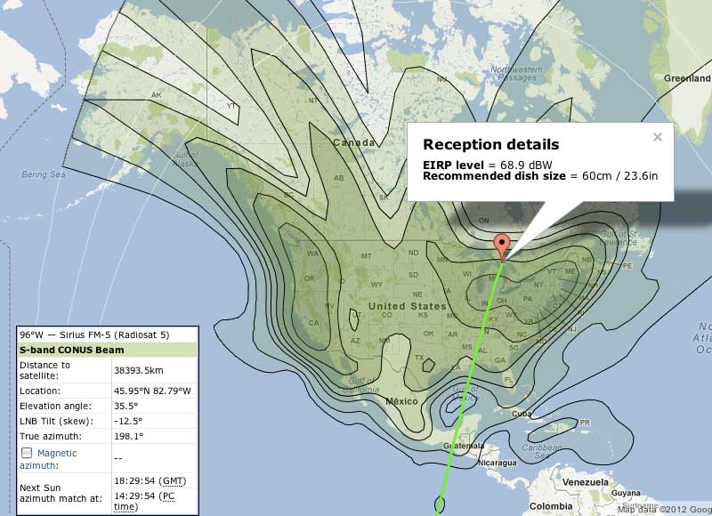
As they like to say in the Newsroom, "Check that!" Upon further research it appears that in October 2009 Sirius Satellite Radio launched another satellite, referred to as Sirius FM-5. Sirius FM-5 has been placed into geostationary orbit at 96-degrees West longitude, or roughly south of central Texas. Sirius FM-5 is said to have increased downlink power and focused beams, concentrated on major metropolitan areas of the USA. See: http://investor.sirius.com/releasedetail.cfm?releaseid=407919 The downlink footprint can be seen here: http://www.satbeams.com/satellites?norad=35493 There is an interactive map which can give you more details about the signal levels at http://mail.satbeams.com/footprints?beam=6093 Here is a look at the Sirius FM-5 downlink footprint and signal level for Northern Lake Huron:
|
| jimh |
posted 04-08-2012 02:23 PM ET (US)
Reception of Sirius FM-5 should be good. The signal in that region is 68.9 dBW EIRP--the equivalent of a 7.7-Megawatt into an isotropic antenna. To calculate the received signal level we need to find the path loss for 2.3-GHz at a distance of 38,393-kilometers. This works out to be a free-space path loss of -191.4-dB. The EIRP transmitter power is 68.9-dBW. To convert to dBm add 30, or EIRP = 98.9-dBm The equivalent in microvolts in a 50-ohm antenna is 5-microVolts. We can ignore line loss in this case since the receiver is probably at the antenna. |
| jimh |
posted 04-09-2012 08:24 PM ET (US)
I have been doing some thinking about the financial investment for creating a service like the Sirius Satellite Marine Weather service. Let's look at the numbers, shall we? To put a satellite into geostationary orbit requires a substantial investment. One knowledgeable consultant says the costs are roughly this: --Satellite manufacture: $150M --Satellite launch: $120M --Launch insurance: $20M --In-orbit insurance: $20M --Satellite operations (15 years): $15M Source: http://www.quora.com/ How-much-does-it-cost-to-set-up-and-launch-a-communications-satellite That is an up-front investment of $310-million, with a $1-million-per-year operational cost. In other words, a very big investment. What sort of revenue can we generate? Let's assume that the marine weather service subscription fee of $25/month is all profit, and all subscribers are year-round. This give us an annual revenue stream of $300-per-year-per-subscriber. We need to offset the operational costs of $1-million-per-year. This means we need 3,333-subscribers just to over the satellite operational costs. To pay back the $310-million investment over 15-years--without any interest--we need to generate $20.7-million each year. We need about 69,000 subscribers every year to cover that. So far we need about 72,333 subscribers to the Sirius Marine Weather just to cover the cost of the satellite. It is unlikely the investors had the $310-million to start up the operation, and they probably borrowed the money. Let us figure the debt on the loan is five percent per year. That is $15.5-million per year to service the debt. This requires 51,666 subscribers to cover that. It looks like the service needs to have about 124,000 subscribers just to break even over the 15-year-operational life of the satellite. We have not allowed for the cost of the ground up-link station, the cost to acquire and distribute the data, and the cost to administer the service. When I look at numbers like this I am glad there were some people who thought they could turn a profit in a business like this. To get over 124,000 people to pay $25-per-month for a marine weather service is quite ambitious planning. Of course, the real revenue generator for Sirius is probably the music listeners. The marine weather data service is just a little bonus income. However, remember that there are four satellites in orbit and a couple of spares on the ground, so the investment is actually more like four times what I have described above. When you look at it in these terms, paying $13 to $25 per month for a customized marine weather data service does not seem like a bad deal. |
| jimh |
posted 04-19-2012 09:08 AM ET (US)
The big retailer CABELA'S now has the Lowrance LWX-1 on sale at $99. See You can also qualify for the $99 pre-paid credit card tie-in offer if you register the receiver and purchase a Sirius Marine Weather subscription. The introduction of all these incentives related to the LWX-1 makes me wonder if the device is approaching its end-of-life and will be replaced by something newer. I think the original introduction of the LWX-1 was in 2009, which, as marine electronic devices tend to age, makes it rather late in the product cycle. Or, the incentives could just be tied to the new boating-fishing season in North America. |
| Mambo Minnow |
posted 04-19-2012 02:25 PM ET (US)
Thanks JimH, perfect timing for me. My old Garmin chartplotter I am replacing had an external GPS antenna. I want to replace it on the mast with a satellite weather antenna since the HDS-5 has an internal antenna. The price reduction fits my budget. I'll use the $100 savings on the HDS unit to get the antenna. |
| bluewaterpirate |
posted 04-22-2012 12:31 PM ET (US)
The value of it in regards to avoiding dangerous weather. http://bluewaterpirate.phanfare.com/5431412_6299606 http://bluewaterpirate.phanfare.com/5431412_6292548 Tom |
| tboltmike |
posted 06-28-2013 02:01 AM ET (US)
Can the antennae be below deck? Can it mounted edge up? I didn't see restrictions in the book. Thanks, Mike |
| kwik_wurk |
posted 06-28-2013 06:03 AM ET (US)
One of my boats has/had XM weather radio, and it was basically useless to me. I was never offshore or between marina's anchorage for more than 48hrs. And out here weather systems are somewhat stable for 24-48hrs in the boating season. Or rather, the pre-departure planning and forecast covers you pretty well. -- However when I boated in the south (Florida) I could see how this would be important due to thunderstorms/squalls that develop. |
| jimh |
posted 06-28-2013 09:19 AM ET (US)
quote: A radio has an antenna. The plural of antenna is antennas. Insects have antennae. Radio signals lose strength as they travel, and cannot travel through conductive material. If you interpose a layer of conductive material between the antenna and the signals you want to receive, the strength of the signals will be greatly attenuated. Non-conductive material usually allows radio signals to pass through, but the attenuation is higher than in the atmosphere. An antenna mounted underneath the deck of a boat may work if the deck is constructed of non-conductive material and is completely dry. Antennas have directive properties. You must point the main lobe of the antenna in the direction of the signals you want to receive. Signals coming from orbiting satellites will come mainly from overhead. You want the main lobe of the antenna pointed to the sky directly overhead. There is little sense in pointing the main lobe of an antenna toward the horizon if you are trying to receive signals from overhead satellites. You are welcome to mount antennas with their main lobe pointing in any direction, but if the main lobe is not pointing at the source of the signals you are trying to receive, the performance will be degraded, often severely degraded if the antenna pattern has a deep null off the main lobe. |
| tboltmike |
posted 06-28-2013 10:01 AM ET (US)
I am humbled and thanks for the clarification. I thought spell checker knew better. Now I'm better informed. Thanks, Mike |
| Hoosier |
posted 06-28-2013 10:33 AM ET (US)
I have the Lowrance LWX-1 Sirius receiver and have stuck it inside the console of my boats. It's worked fine since the consoles are fiberglass, not metal. I make sure it's right side up. |
| jimh |
posted 03-24-2014 09:23 AM ET (US)
Looking at the LWX-1 Marine Weather Receiver cost and rebate offer from the perspective of two years later, it was one good deal. The present-day Sirius Weather Radio receiver is the NAVICO WM-3, sold by both Lowrance and Simrad, for a rather impressive sum of $700 to $800. WM-3 SiriusXM Satellite Weather and Radio Module In contrast, the offer to get the LWX-1 for between $50 to $100 after rebate was a very good deal. The new WM-3 literature says: "WM-3 operates with the new SiriusXM North America equatorial Satellite System" The present system of Sirius geostationary satellites appears to be FM-5, launched in 2009, and FM-6, just launched in 2013 and declared operational in December 2013, only a few months ago. FM-6 is in geostationary orbit around 120.5-degrees-W longitude FM-5 is in geostationary orbit around 96-degrees-W longitude Sirius also has XM-5 and XM-3 in geostationary orbit around 85-degrees-W longitude I have not been able to unravel the details of exactly which satellites transmit the Marine weather data |
Powered by: Ultimate Bulletin Board, Freeware Version 2000
Purchase our Licensed Version- which adds many more features!
© Infopop Corporation (formerly Madrona Park, Inc.), 1998 - 2000.