search | FAQ |
profile | register | author help
|
|
|
| Author | Topic: DSC Radio Position Request |
| jimh |
 posted 07-17-2012 09:02 AM ET (US)
 A feature of digital selective calling (DSC) VHF Marine Band radios is the ability for one radio to request a position report from another radio. This is called position polling. When a DSC radio receives a request for its position from another radio, the polled radio can be configured to answer either automatically or to require manual approval before responding. When we were in the Apostle Islands National Lakeshore area last week, we were planning to rendezvous with our friends aboard HOLLY MARIE. We knew the maritime mobile service identity (MMSI) of the HOLLY MARIE. We did not know the boat's location, so we sent a DSC request for a position poll to the HOLLY MARIE. As it happened, the HOLLY MARIE was in radio range, laying about 12-miles to the Northeast, and her DSC radio received our DSC call. The DSC radio on the HOLLY MARIE responded with the position of the boat. On the HOLLY MARIE their DSC radio is connected to their GPS receiver, and the GPS receiver provides position data to the radio. Our DSC radio is connected to our chart plotter via a NMEA-0183 serial data connection, and our radio received the position data from the HOLLY MARIE, and also sent the position information to our chart plotter. The chart plotter drew the location of the HOLLY MARIE on our navigation chart as a new WAYPOINT. The screen presentation of the HOLLY MARIE position from the DSC position poll request looked like this:
The chart plotter marked the position as a waypoint and gave the waypoint the name "3381061850DSC01." The first part of that string is the maritime mobile service identity of the station sending the position. The suffix "DSC01" most likely refers to the source as being from a digital selective calling radio. I don't know if the "01" is a serial number that will be incremented on the next position request. We'll have to investigate further. The Waypoint on the chart plotter also included the following detail "Undesignated distress." This is an unfortunate notation, as there was no distress involved in this position request. This notation may have been created because a field in the DSC message was left blank or sent as a "0", and the chart plotter interpreted this as a default message, "undesignated distress." In order to obtain this sort of information from your DSC radio, you need to connect the radio to both the GPS receiver and the chart plotter. The GPS receiver sends the position data to the radio, and the radio will transmit this data when requested to other stations. The radio must also be connected to the chart plotter, so that when the radio receives position information from other stations, it will output the data to the chart plotter for display. If the radio, the GPS recevier, and the chart plotter are all NMEA-2000 devices, the interconnection will occur automatically when all three are on the same network backbone. If the devices are NMEA-0183 devices, you have to discretely wire a connection from the GPS receiver to the radio, then from the radio to the chart plotter. |
| jimh |
posted 07-17-2012 09:29 AM ET (US)
The two radios involved in this exchange were both CLASS-D DSC radios. Typically a CLASS-D rated radio is needed to provide these features. The older VHF Marine Band radios certified to RTCM SC-101 specifications typically do not provide these features. Also, the two radios in this exchange were from the same manufacturer, STANDARD-HORIZON. However, radios from different manufacturers should interoperate if they conform to the NMEA specifications and support the NMEA sentences DSC and DSE. |
| 6992WHALER |
posted 07-18-2012 01:28 PM ET (US)
The "undesignated distress." detail is interesting. I don't know if my radio has the technology but I will check and see if the radio kept a log of this position request response. I think you are probably correct that it is an interpretation of data mistake made by your chart plotter. If not I think your DSC radio would have sounded an alarm. My Garmin Chart plotter marks the way point of a DSC position request the same way it marks any other way point. Nothing fancy just the next available number. It gives me the option to rename it before I save it. |
| Chuck Tribolet |
posted 07-18-2012 10:58 PM ET (US)
I agree with 6992WHALER, the distress indication is probably a bug in your chartplotter, or possibly in the other guy's radio. I'd report it to your Chartplotter manufacturer, in writing. But I don't think class D is required. It's always worked One key consideration is whether the other guy's radio will Chuck |
| jimh |
posted 07-19-2012 03:26 AM ET (US)
The position polling request is not really part of the criteria for a DSC radio to earn a CLASS-D rating, but typically the newer radios which are CLASS-D rated tend to have the position polling feature. I think the use of digital selective calling to provide remote position polling requests was initiated by STANDARD-HORIZON in their radios. I suspect that Chuck has a STANDARD-HORIZON radio, and his radio probably precedes the epoch when STANDARD-HORIZON began to make radios with a CLASS-D rating, but before that they had already added support in their radios for the remote position request and reply. I had not thought of the usefulness of leaving your DSC radio set to automatically reply to a position request as a way for emergency responders to be able to locate your boat if you had gone overboard. That is a very useful notion. I think I have my DSC radio set to automatically reply, but I am now going to check it to be certain. As Chuck described, it could be very helpful in a search for your boat if you were no longer aboard, or even if you were aboard but could not get to the radio to manually send a reply. The remote position polling is accomplished--as far as I can tell--using the NMEA sentences DSC and DSE. Unfortunately, I cannot find any detail about these sentences. All the information about NMEA sentences is kept confidential by NMEA, but for many of the sentences there has been reverse-engineering of the message format and these details have been revealed by various enthusiasts who are not violating any confidentiality agreement with NMEA. However, for the two sentences DSC and DSE I have not found any detail or elaboration of how those datagrams are constructed. WIthout knowing what the details of those sentences are supposed to be, it is hard to judge what device in the communication chain added the "undesignated distress" notation to the data exchange that occurred between the HOLLY MARIE and my boat via DSC radio. It seems strange that something that could be so important to boater safety is the property of a manufacturing association and is treated like a state secret. I think you can find more publicly-available information on making an atomic bomb than you can about the NMEA sentences DSC and DSE. Below is a screen capture of the details of the waypoint that was created on my Lowrance HDS-8 when my Standard-Horizon radio sent the remote position information that it received from the HOLLY MARIE:
Exactly how this waypoint got the notation "undesignated distress" is not precisely known. (Also, the distance and bearing to the waypoint are not indicated because at the time when I grabbed this screen image the chart plotter did not know its own position, that is, its GPS had not yet obtained a position fix solution.) |
| jimh |
posted 07-19-2012 03:40 AM ET (US)
ASIDE to Chuck: with that BoatUS MMSI number (338 000069), you must have been one of the earliest registrants to get an MMSI from them. I think you were at the event horizon of MMSI registration with BoatUS. My BoatUS MMSI is much higher, 338 040 079. I also have an FCC-issued MMSI. It starts with 367.... It is also curious to note that the waypoint designator appended a zero to the MMSI number. The MMSI of the HOLLY MARIE is 338 106 185, but the waypoint created has an extra zero at the end. |
| jimh |
posted 07-19-2012 03:53 AM ET (US)
Here is another oddity: all MMSI's assigned by the FCC to vessels end in a zero. BoatUS says this is done to conform with the ITU database requirements. A Wikipedia article has some information on MMSI formats, too. Some ships with satellite terminals must have an MMSI with three trailing zeros. http://www.boatus.com/mmsi/MM1.htm#q14 |
| Chuck Tribolet |
posted 07-20-2012 02:28 PM ET (US)
I knew that Boat US was going to start issuing MMSIs, and was checking their website a couple of times a day. I got my MMSI within a couple hours of their going live with it. I'd had a DSC radio for some time, but had resisted shelling Thanks, Boat US. Chuck |
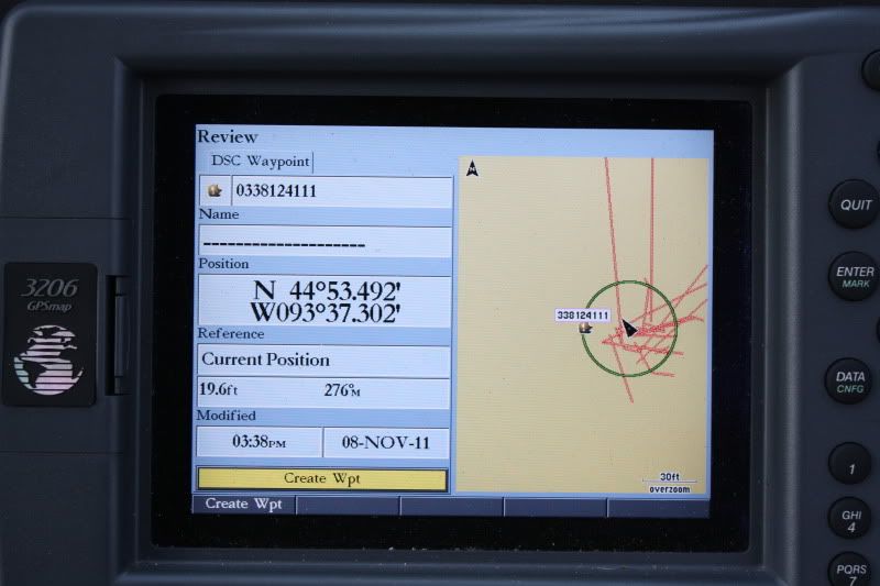
| 6992WHALER |
posted 07-22-2012 11:26 AM ET (US)
On further review, my Garmin 3206 Chart plotter does show the way point of a DSC position request as the boat's MMSI number. With a 0 added to the front.
You can clearly see this in the picture showing the Garmin's Screen. Also see this earlier article. |
| jimh |
posted 09-02-2012 11:35 PM ET (US)
Here is a follow-up on the subject of the Lowrance HDS displaying the remote position poll request as a DSC call with the category of "undesignated distress." I sent an email to Lowrance asking about the description of the waypoint as "undesignated distress." My email was really just about a cut-and-paste of the initial article in this discussion, including the screen capture. Here is the reply I received, which I reproduce verbatim:
quote: |
| jimh |
posted 09-02-2012 11:45 PM ET (US)
Notwithstanding the reply from Lowrance that the description of "undesignated distress" is normal, I don't think this is the right way to handle a routine position poll response. There is no distress nature to the call. It is just a request for position. Here is some commentary about the "undesignated distress" category. It seems it is the default description in a distress call. This comes from a secondary source: http://www.inmarsat.com/Maritimesafety/dsc.htm
quote: |
Powered by: Ultimate Bulletin Board, Freeware Version 2000
Purchase our Licensed Version- which adds many more features!
© Infopop Corporation (formerly Madrona Park, Inc.), 1998 - 2000.