search | FAQ |
profile | register | author help
|
|
|
| Author | Topic: RESCUE 21 VHF Radio Coverage |
| jimh |
 posted 02-09-2013 09:11 AM ET (US)
 I have found an excellent resource for information on the predicted coverage of the United States Coast Guard's new RESCUE 21 radio system for the VHF Marine Band. Very large-scale coverage charts are available for each Coast Guard district. You can download high-resolution images of the coverage charts from http://www.navcen.uscg.gov/?pageName=mtNds Look under the sub-heading VHF Distress Coverage Charts. |
| 6992WHALER |
posted 02-09-2013 02:40 PM ET (US)
I wish the coverage was shown for a 25w transmitter as well as a 1 watt. I wonder how different the maps would look. The Upper Mississippi River is not an active link. I wonder what the plans are for it? |
| 6992WHALER |
posted 02-09-2013 02:45 PM ET (US)
[Quotes material from USCG Website; see link below] Rescue 21: Western Rivers Source: http://www.uscg.mil/acquisition/rescue21/westernrivers.asp |
| David Pendleton |
posted 02-09-2013 05:35 PM ET (US)
Note there is no coverage for [Isle Royale National Park area]. |
| jimh |
posted 02-09-2013 06:52 PM ET (US)
Increasing the transmitter power of the vessel radio station to 25-watt from 1-watt will increase the coverage range. The power ratio 25:1 expressed in decibels is almost 14-dB. That is quite an increase. You can expect that the range will increase about 20-percent for each 3-dB of added gain. On that basis, you might calculate the path will increase by a factor of two with 14-dB gain, perhaps even more. That is a really rough estimate. Also, an increase in antenna height on the boat will help extend the range, too. |
| 6992WHALER |
posted 02-09-2013 08:36 PM ET (US)
I was told at the USPS National conference last year that in reality the coast guard was picking up DSC signals from handheld radios on the surface from 50 mile out. I have no documentation but the presenter was involved in writing the curriculum for the US Power Squadron Marine Communication course. |
| jimh |
posted 02-10-2013 09:22 AM ET (US)
When calculating the signal level on a radio circuit, the path loss is an important consideration. Path loss is the attenuation of the signal that occurs in the propagation path. There are various ways to estimate path loss. In free space, path loss obeys a well-defined characteristic. Over actual earth and terrain, path loss is more difficult to model and characterize. The general behavior of path loss as a function of distance is characterized by a term in the form of n x log(d) where n is some coefficient and d is the distance. For free space the relationship is usually described as loss = 20 x log(d) If we increase power in a circuit, we add gain. This means we can tolerate more path loss. In the case above, going to 25-watts from 1-watt adds 14-dB of gain to the radio circuit. We could estimate the increase in distance by solving the above relationship 14 = 20 x log(d) d = 10^(0.7) = 5 If the path were in free space, no intervening Earth or terrain, an increase of 14-dB gain in the circuit would permit the distance to increase by five. Unfortunately, over real Earth and terrain, path loss increases at a faster rate with distance than in free space. There are many ways to model or predict path loss. A simple model is to assume that path loss behaves according to loss = 40 x log(d) If we use that approximation, we can find the increase in distance resulting from the addition of 14-dB of gain as 14 = 40 x log(d) d = 10^(0.35) = 2.2 This is the estimate I mentioned earlier. Adding 14-dB to the circuit may produce an increase in range by a factor of about 2. In the case above, the gain is only added in one direction, that is, the transmitter power of one station was increased to 25-watts from 1-watt. There was no increase in the gain in the circuit in the other direction. However, it is likely that the other station in the circuit was already transmitting at 25-watts, and the circuit was being limited by the lower transmitter power of the 1-watt station. We can assume that the path would remain a two-way path. For more detail on path loss calculations, see my article Estimating Path Loss on Marine Non-Line-of-Sight Paths The coverage predictions shown in the United States Coast Guard website on the RESCUE 21 system are noted as being based on the Longley-Rice model for prediction of propation over irregular terrain. For more on that model see http://en.wikipedia.org/wiki/Longley–Rice_model I am not familiar with the method, but it appears to be a standard method often used in predicting propagation at VHF. There is an on-line calculator that uses the Longley-Rice model. It might be interesting to explore a few paths using this model to see what sort of coverage might occur. Of course, the details of the USCG RESCUE 21 site would have to be known. Details such as antenna gain, height of antenna, and accurate location of antenna would be necessary to have to use the calculator. See |
| jimh |
posted 02-10-2013 09:49 AM ET (US)
Dave notes the coverage areas shown in Lake Superior do not include Isle Royale. The USCG has the following to say about boaters and radio: Your VHF radio is intended mainly for short range communications, generally 5-10 miles, and at least 20 miles to a USCG station. To communicate at longer ranges, you will normally need a satellite telephone or an MF/HF marine radiotelephone. |
| 6992WHALER |
posted 02-10-2013 12:59 PM ET (US)
It would be interesting to know if the Isle Royale Park Service is monitoring DSC radios. I would count on them for help over the Coast Guard. Does the Canadian Coast Guard Monitor DSC? |
| jimh |
posted 02-10-2013 02:39 PM ET (US)
Use of DSC radios is a global initiative, part of the General Maritime Distress and Safety at Sea (GMDSS) program. I would hope the Canadian radio watchstanders are using radios that comply. It is a good topic for further investigation. |
| jimh |
posted 02-10-2013 02:44 PM ET (US)
GMDSS watch is classified by sea areas. Canada has declared their GMDSS Watch in Sea Area-1 to only be ocean-coastal areas. A graphic depicts the areas considered by Canada to be in their Sea Area 1 range: http://www.ccg-gcc.gc.ca/folios/00027/images/gmdss-canada.gif See: http://www.ccg-gcc.gc.ca/eng/CCG/SAR_Gmdss With the installation of RESCUE 21, the United States Coast Guard may be about to declare the areas covered by RESCUE 21 as the Sea Area 1 coverage. I don't think they have formally done it. |
| jimh |
posted 02-10-2013 11:59 PM ET (US)
According to the summary record from a September 2012 meeting of the GMDSS Implemenation Task Force:
quote: I have not been able to find any official notice that the USCG has declared a GMDSS Sea Area 1 to date. Note that it is anticipated the Great Lakes will be in the designated Sea Area 1. Also note that recreational vessels are voluntarily equipped and are not subject to the mandatory upgrade to VHF-DSC capability. |
| jimh |
posted 04-24-2013 09:03 PM ET (US)
From the information I can find, it appears that the goal of the RESCUE 21 installation for coverage is to provide a minimum range of 20-mile offshore coverage that can detect a transmission of 1-second duration from a transmitter of 1-watt using an antenna of height 2-meters above the water. This is the plot shown in the coverage maps. Even with the restriction of those criteria, many of the coverage maps show that in some installation in the most favorable offshore direction there is coverage to more than 40-miles. Those installations are probably ones with very favorable sites on-shore, that is, where the antenna is higher above sea level and extends the coverage beyond the minimum 20-mile contour. It may be interesting to estimate the increase in the coverage that could be obtained if the vessel station were using more than 1-Watt of power. Let us assume that a vessel may use a standard 25-Watt radio, that the radio delivers an actual 20-Watts to the antenna, and that the antenna has 3-dB of gain. This would increase the transmitted signal from the vessel to 40-Watts from the 1-Watt signal of the RESCUE 21 coverage prediction. Now we can apply some reasonable adjustment in the coverage range based on the higher power of the vessel transmitted signal. Compared to a 1-Watt signal, a 40-Watt signal will be an increase of 16-dB. With 16-dB great signal, we can extend the path a distance that represents a loss of 16-dB, and the received signal should be the same. The problem is determining what added path length can be achieved with an increase in signal of 16-dB. The model for path loss in free space represent the least possible loss, or the greatest possible increase in path length that could occur. The free-space model calculates path loss in dB as a function of distance by the relationship dB = 20 log (distance) By rearranging this we can find the distance as a function of change in gain, according to distance = 10^(dB/20) Solving this for 16-dB we find the distance (ratio) is going to be 6.3. This means that if the RESCUE 21 has sufficient coverage for a 1-Watt signal at 20-miles, it has coverage for a 40-Watt signal to over 125-miles. This seems very optimistic, and is probably too optimistic. As I mentioned, the free-space model is the absolute best outcome for increase in distance. A more conservative model of path loss calculates path loss in dB as a function of distance by the relationship dB = 40 log (distance) This is a model that is often used for predicting path loss over real terrain. If we use this model, we can calculate the added path length for a 16-dB increase in signal. This model predicts the coverage will increase to a range of 50-miles from 20-miles when the transmitted signal increased 16-dB. This seems much more likely to be obtained in the real world. The RESCUE 21 coverage prediction is also rather stringent in its demand to be able to detect a 1-second transmission. In radio propagation there is often a continual change in atmospheric conditions, resulting in the signal level on a path varying up and down. The RESCUE 21 model appears to account for this by imposing the requirement that the signal be detected in any one-second interval. In a real world situation, a signal transmitted for a longer duration is more likely to be detected. I believe that this will also tend to increase the range of RESCUE 21. In summary, the RESCUE 21 system seems to have been designed to provide at least 20-mile coverage offshore in circumstances that are rather minimal for the transmitting station: only 1-watt of power is used, the antenna is only 2-meters high, and the duration of the transmission is only one second. Even with those limitations, the coverage maps show RESCUE 21 often exceeds the 20-mile range of coverage in many sectors. If the transmitted signal is increased to 40-watts of power, the coverage should increase. With a 40-Watt signal, it appears that a range of 50-miles for RESCUE 21 may be possible. The RESCUE 21 system coverage maps show that some sectors have extremely good coverage, and within the restrictions specified (1-Watt, 2-Meter, 1-Second signal) the coverage maps show a range of more than 20-miles. Below is a segment of RESCUE 21 stations on Lake Michigan. The station at Bucks Corner provides coverage to 45-miles, and the station at Fayette provides coverage to 42-miles.
|
| K Albus |
posted 04-26-2013 10:19 AM ET (US)
Are these coverage maps that we always see based on empirical test results, or are they simply a representation of expected range based upon known variables? |
| jimh |
posted 05-01-2013 08:50 AM ET (US)
The coverage maps are predictions. The link to the maps says: "Charts showing predicted areas of VHF coverage from shore can be downloaded in .jpg format. As indicated on the charts, coverage plots assume a mobile transmitter power of 1 watt with an antenna two meters above water level."
"Coverage based on the Longley Rice Irregular Terrain Model on receiving a one (1) second transmission from a one (1) watt transmitter with an antenna two (2) meters above water level" |
| jimh |
posted 05-01-2013 09:34 AM ET (US)
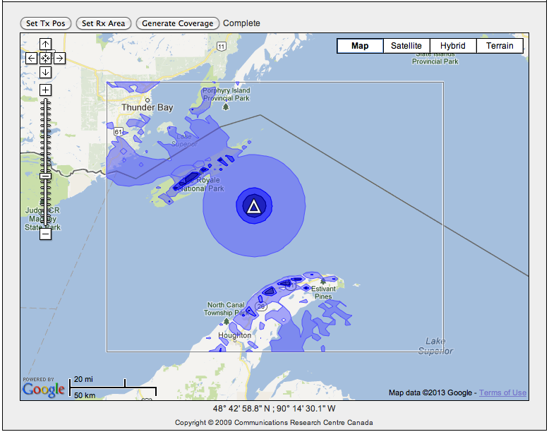
There is an on-line coverage calculator that used the Longley-Rice Irregular Terrain Model at http://lrcov.crc.ca/main/index.php I have calculated the coverage for a vertically polarized antenna of gain 5dB, transmitter power 25-watts, with an antenna height of 4-meters (about 15-feet) located in Lake Superior and Southeast of Isle Royale. The calculator generated the coverage map shown below. This one is for a receive antenna with only 1.5-meter height above ground. The light blue area is a field stength of 10 to 30 dBuV/Meter, which is probably on the edge of communication quality signal. The blue area is 30 to 40 dBuV/Meter, and the dark blue greater than 40 dBuV/Meter, or very strong signals. The model predicts coverage with good signals to the higher parts of the land on Isle Royale and the Keweenaw Peninsula. It also predicts some coverage beyond those areas due to the scattering of the signal on the higher land. Here is the plot:
Also, in the Longley-Rice model there are factors for confidence and time available. In the above the prediction is for only 50-percent confidence and time, and also the signal levels are very marginal in the light blue areas. |
| Hoosier |
posted 07-02-2013 09:47 PM ET (US)
I guess this diagram raises the question: what if there isn't a Rescue 21 receiver in range of your transmitter? From the diagrams Dave cited the western Lake Superior stations can't "see" around Isle Royale. The Canadain system has good coverage for the eastern approaches to Isle Royale and superb coverage for the west coast of Isle Royale. Go to page 4-28 of this http://www.ccg-gcc.gc.ca/folios/00026/docs/part-4ae-2008-eng.pdf |
| jimh |
posted 07-03-2013 09:55 AM ET (US)
The coverage map contained in the 50-page PDF file (linked above) is also available from http://continuouswave.com/whaler/reference/graphics/RadioCoverageMaps/ VHF_CoverageMapGreatLakes.jpg This saves you the trouble of downloading 50-pages of document. |
Powered by: Ultimate Bulletin Board, Freeware Version 2000
Purchase our Licensed Version- which adds many more features!
© Infopop Corporation (formerly Madrona Park, Inc.), 1998 - 2000.