 ContinuousWave
 Whaler
 Moderated Discussion Areas
ContinuousWave: Small Boat Electrical
Returning to SONAR Targets
Moderated Discussion Areas
ContinuousWave: Small Boat Electrical
Returning to SONAR Targets


search | FAQ |
profile | register | author help
|
|
ContinuousWave Whaler Moderated Discussion Areas
ContinuousWave: Small Boat Electrical
Returning to SONAR Targets
|
| Author | Topic: Returning to SONAR Targets |
| jimh |
 posted 11-23-2014 05:03 PM ET (US)
posted 11-23-2014 05:03 PM ET (US)  
Let us say we are boating and looking for a particular target on a SONAR. (The target is stationary and is on the sea bottom.) The water depth is 100-feet. We are using a SONAR transducer with a cone angle of 30-degrees of flat response. While boating we observe a target on SONAR. We immediately mark our position on our chart plotter as determined by our GNSS receiver. Sometime later we try to return to the position marked and can't find the target. What caused the errors? The first error in this process occurs in the SONAR. The target reflection is occurring from some point on the bottom that is in the cone of the SONAR signal. We assumed a cone angle of 30-degrees. If the depth is 100-feet, then the radius of the circular area on the bottom that intersects our SONAR cone is defined by circle radius = tan(coneAngle/2) x depth --or-- circle radius = tan(15) x 100 = 26.8-feet The actual target causing the reflection we see on the SONAR screen could be as far as 26.8-feet away from the SONAR transducer's position directly overhead on the sea bottom. The second error in the process occurs when the chart plotter marks the position. The position recorded is the position of the GNSS sensor, not the SONAR transducer. On a small boat it would be common that the SONAR transducer was mounted on the transom while the GNSS antenna was mounted at the helm. These two locations could be 10-feet apart. This is the GNSS antenna offset error The third error occurs when the GNSS receiver deduces the position of its antenna. The deduced position is subject to many influences for accuracy. A nominal accuracy for an autonomous GPS without any assistance is plus or minus 5-meters in the horizontal plane. That is about 15-feet of error. This is the GNSS position error. If we are particularly unlucky, all of these errors will lay on a straight line, and thus they will be additive. This gives us a maximum error for the waypoint position that is supposed to mark the SONAR target of 26.8-feet + 10-feet + 15-feet = or about 50-feet of error. To get back over this target at some time in the future, we navigate to the recorded position. Our navigation is again subject to the error of the GPS position, or 15-feet. We can position the GPS sensor at the same position as the recorded waypoint, but we can only count on being within a circle of 15-foot radius. If we are again unlucky, the GPS position error will be in the opposite direction that it was when the waypoint was recorded. So not only are we 15-feet away from where the target is located by the error in the initial position, we are another 15-feet away due to the second GPS position error made on the return. Ouch, now we are 30-feet away from the real position of the target. But things are not done getting worse. If the orientation of the boat is also very unlucky for us, then the GPS tells us we are back to the original position plus 15-feet of error, the boat orientation will be aligned in the worst way, putting our SONAR transducer another 10-feet away from where it should be to find the target. Total error in re-locating to the waypoint is 40-feet. Now we have to consider the SONAR cone problem, but this time it actually helps us. Even though we might be out of position by 40-feet, we know that the SONAR cone is going to cover a circular area on the bottom of 25-foot radius. This means we have a good chance of seeing the target, even though we have positioned the SONAR transducer 40-feet away from where we though should be. In actual use, the errors do not tend to align for the worse outcome. The errors are likely to be uncorrelated. We repeat the analysis with the consideration that the errors will add as the root sum of squares: Error = [ ( (SONARconeRadius)^2 + (GNSS antenna offset)^2 + (GNSS position error)^2 ]^0.5 Error = (26.8^2 + 15^2 10^2)^0.5 Error = 32-feet Our initial position is now only likely to be 32-feet in error at most from where the actual target is located on the sea bottom. When we return to our stored waypoint, our GNSS position error and GNSS sensor offset also will be uncorrelated. The likely error will be Error = [ (GNSS antenna offset)^2 + (GNSS position error)^2 ]^0.5 Error = (15^2 + 10^2)^0.5 Error = 18-feet This makes the chances of finding the original target better. We should be back to within 18-feet of the actual boat position that found the first target, and we will be searching with a SONAR that paints the bottom with a 26.8-foot radius. We should see something from that target on our display. If the cone angle of the SONAR transducer is smaller, or if the water depth is shallower, or if the GPS receiver position is more accurate (as can be obtained with SBAS augmentation), then these errors are all smaller, and there is even a better chance of returning to the initial target. |
| fno |
posted 11-23-2014 06:04 PM ET (US)
JimH's math is beyond me, at least at this hour of the day but we fish a lot of rocks, reefs, and wrecks. We typically motor to a waypoint, and within a few hundred feet concentrate on the sonar for structure and or baitfish in the water column. When we do pass the likely spot we toss a marker buoy with 6lbs of lead. Unless there is a huge current we can usually go back and find the spot on another pass or two. This is also when we also start gauging the wind and current for anchoring purposes. Anchoring up directly on the spot can also be problematic depending on the current and the wind direction. |
| jimh |
posted 11-24-2014 06:39 AM ET (US)
We have tried to find some ship wrecks on the bottom by using just latitude and longitude coordinates, but typically, as we approach the wreck site, we see a marker buoy tied onto the wreck. It is a lot easier to find the wreck with SONAR when you start with the marker buoy as a reference. The last time we were out wreck hunting, as we approached the wreck site, I told my crew to watch for a marker buoy, and I was going to keep my head down, fixed on the chart plotter and SONAR, navigating only to the waypoint by that reference. When we reached the waypoint there was no target on the SONAR, so I began a search pattern. In a short time we got a SONAR echo of the wreck, and, of course, when I looked up we were right on the marker buoy. But I wanted to see if I could find the wreck without relying on the marker buoy. We have also been on some wrecks that had a market buoy but it was apparently tied on with a rather long line. The wind or current sets the marker well off the actual wreck, so far that you don't see it on SONAR at the buoy location. But, of course, you deduce the direction of the buoy's line to the wreck, and easily find the wreck upstream in the wind and current. I will make some graphics to show the position ambiguity better than I can describe it in narrative. |
| jimh |
posted 11-26-2014 10:07 AM ET (US)
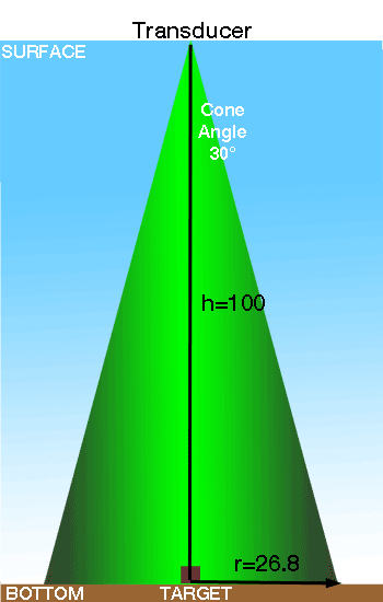
The relationship between the target on the bottom and the SONAR transducer is illustrated below.
Because of the beam spreading of the sound signal in the cone, the target could be anywhere on the bottom within the radius shown and still return an echo to the transducer. The cone angle is drawn for 30-degrees. The radius is calculated on half that angle, or 15-degrees. The radius is calculated by the relationship r= TAN(15-degrees) x 100-feet. The tangent of 15-degrees is 0.268. At a depth of 100-feet the SONAR cone paints the botton with sound in a circle of radius 26.8-feet. This should explain the math, well, actually the geometry, of the problem. |
| jimh |
posted 11-26-2014 01:41 PM ET (US)
Regarding how to add up errors the might occur. If there were some correlation between the errors we could just add them together and take the average of that sum. In this case the errors are not correlated. We take the sum of the squares of the errors and then take the square-root of that sum. To understand if the errors are correlated or uncorrelated, you can think of the relationship. If we measured two dimensions and used the same ruler, any error in the measurements would be correlated because they used the same ruler and the same person did the measuring. If the ruler were wrong or the person who used the ruler make the same mistake with every measurement, then the errors would be correlated. In the case of this problem, the orientation of distance of the offset between the GPS sensor and the SONAR sensor is quite random, and the orientation of the offset distance between the true position and the GPS position is also random, and neither effect each other. These errors are uncorrelated. |
| jimh |
posted 12-27-2014 08:46 AM ET (US)
I re-drew the illustration (above) of the sound cone from the transducer, but with some better shading to show that as the sound energy travels outward from the transducer its intensity is varying. In the bore sight of the cone, the intensity is higher than at the fringes of the cone. When one speaks about a cone angle, what is being described--usually--is the geometric shape of the signal intensity when the sound power has decreased to half the power of the sound in the main beam. By shading the cone from bright green to a dark gray-green, I hope to illustrate this better. There is sound energy or power beyond the nicely defined cone shape, but it is not illustrated in the drawing because that sound has decreased in power to less than half the power in the main beam. Power levels are often compared by using the relationship called a deciBel. When a power decreases to half its original power, we say the power has changed by -3dB. When a SONAR equipment manufacturer says a transducer has a certain cone angle, say 30-degrees as shown above, he means that the power density decreases to half in a spot beam of 30-degrees width. Targets that are outside of the 30-degree cone can still reflect sound back to the transducer, but they won't reflect as much sound back as they would have if they were in the main beam. |
| jimh |
posted 12-27-2014 10:29 AM ET (US)
There is another consideration of the SONAR transducer signal: the pattern of the cone may not be a circle. What we have been calling a cone may be conical in cross section when viewed from the water surface looking horizontally. If viewed from the water surface looking downward, the projection of the sound power may not be in a circle but instead in an ellipse. The beam may be shaped by the transducer to have a wider width in the Port-Starboard axis than in the Bow-Stern axis. This is sometimes called a fan beam. This may improve target location in one axis. |
| |
Powered by: Ultimate Bulletin Board, Freeware Version 2000
Purchase our Licensed Version- which adds many more features!
© Infopop Corporation (formerly Madrona Park, Inc.), 1998 - 2000.