search | FAQ |
profile | register | author help
|
|
|
| Author | Topic: Grand Traverse Bay June 2012 |
| jimh |
 posted 06-24-2012 07:35 PM ET (US)
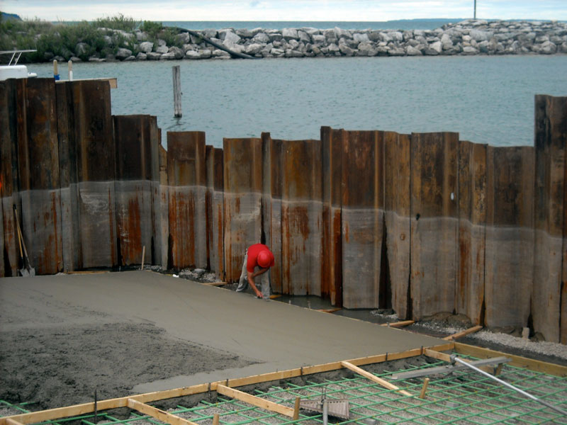
 Here is a very quick account of a week-long cruise around Grand Traverse Bay we took in June of 2012. Grand Traverse Bay Cruise 2012 Day One, Sunday, June 10, 2012 Beverly Hills to Elmwood Township Marina by highway, about 230-miles Day Two, Monday, June 11, 2012 Departing Elmwood at 2:30 p.m. Dinner was at THE GARAGE, a new bar and restaurant in Northport. Chris had whitefish. I had a burger. We watched the first period of Game Six of the Stanley Cup. LA KINGS went out to a 3-0 lead and looked in control of the game. We did not stay for second period. The new boater lounge had a high-definition television, but the cable feed was not yet connected. Day Three, Tuesday, June 12, 2012 Laying Northport Marina, with all new bath house facilities. Changed E-TEC engine oil rate setting to XD100-only setting. This should reduce oil consumption to about 1:70 oil-gasoline ratio. Added 25-gallons of gasoline fuel. The REC 90 pure gasoline was from a delivery last fall. Price was $4.03/gallon. Incremented FUEL REMAIN by 25 to 62.5-gallons (on both the Lowrance HDS/Memory Module and the ICON gauges.) Departing Northport approximately 11:00 a.m. Leland Harbor is under renovation, as follows: --main channel entrance is being dredged RAMP DETAILS The down slope of the ramp is 14-percent, or an angle of 8-degrees downward. The ramp is to be formed as a cast in place 8-inch thick concrete slab laying atop 6-inches of aggregate stone. The end of the ramp is to be 4.4-feet below water at low water datum (LWD). At the ramp end there is to be a 1-in-5 downslope to the lake bottom to 8-feet below LWD. The ramp is to be 8-inch thick concrete with #6 steel re-bar on 12-inch centers set E/W [each way] over 6-inches of aggregate of 2006 MDOT railroad specification. The ramp surface is to have a finish groove set 60-degree to the slope of the ramp. The concrete is to have a 28-day compressive strength of 4,000-PSI. Entrained air content to be 6.5-percent, plus-minus 1.5-percent. At end of ramp a rubber "prop wash" deflector is to be installed using 0.75-inch thick and 18-inch high rubber sheets with 1-inch overlap at seams for a total of 49-feet width. The ramp is 45-feet wide and 71.7-feet long. A central skid pier is to be 44-feet long and 5-feet wide. ABONMARCHE CONSULTANTS, Manistee, Michigan, were the architect-designers. We went to dinner at THE BLUEBIRD. Chris had Bluebird-style whitefish. I had blackened prime rib. My dinner was over-cooked and not great. Go with the classics--live and learn. Relaxed in boater's lounge. Read interesting historical article about Lake Superior Iron Smelter at Leland. Discovered that Lake Leelanau was formerly Carp Lake, and the river Carp River. The Iron works ran for about 15 years. Hardwood was cut from Carp Lake and floated down on barges. Beehive kilns turned the hardwood into coke. Iron ore was brought across Lake Michigan by boat to be turned into pig iron in the furnace. Iron ingots were loaded on boat. The business failed due to high labor cost of creating coke and unprotected harbor.
Laying Northport Harbor. Overnight a high pressure system blew in from the North, making for clear skies and very low temperatures. The Milky Way was very prominent last night. This morning it is unseasonably cool, and the wind is from the Southwest. The crew from the dredge arrives early, about 6:30 a.m., and starts the large diesel engine, awakening us. The crew yell back and forth to each other over the noise of the dredge engine as they maneuver in a small work skiff to tow an auxiliary barge from the dock to the dredge. Construction crew arrives and begins driving piling for dock. Their air compressor is very noisy and runs poorly. They tear down the fuel system and clean out some filters. I say to them "That air compressor runs like the engine is from a 1924 Ford truck." The crew replies, "That's because the engine is from a 1924 Ford truck." The crew foreman is an old guy with a white beard. He jokes with me about (me) being old. I visit with the owner of DAZY, a 38-foot cold-molded sloop. Departing Leland about 10:00 a.m. We head North at displacement speed with a gentle following sea from the Southwest. After rounding point, we encounter wind and waves from the South-Southeast. We run on plane at moderate speed into the waves at 25-MPH, heading for Old Mission Peninsula. About 1:30 p.m. we drift for lunch in Old Mission Harbor. After lunch we continue South along the East shoreline of Old Mission Peninsula, going all the way to Traverse City in the East Arm of the bay. Then we head North along the Eastern shore, arriving in Elk Rapids about 3:10 p.m. Dinner was at PEARL'S. Chris had three appetizers: crayfish, fried green tomatoes, and crab cakes. I had Southern-style fried chicken. Drinks were a dollar off before 7 p.m. We walked back. On path we discovered another pig iron furnace relic, on the site of the old motel (now Condo's) where we stayed in 1998. Day Five, Thursday, June 14, 2012 Laying Elk Rapids Small Craft Harbor Marina. Weather forecast (land) Copying NOAA WX-7 KZZ33 CMU full quieting BARO = 1005 mBar at 9 a.m. (from E-TEC). Departing Elk Rapids about 10:00 a.m. heading for Northport. After lunch ran on plane across Grand Traverse Bay to Suttons Bay, then coasted North along shore to Omena. After Omena ran on plane to Northport, arriving about 4 p.m. Asked for different slip assignment to avoid bright lighting from boardwalk Went to dinner with Martha and Con Balfor at KNOT JUST A BAR in Omena. I had a good burger; Chris had fish tacos, and Martha and Con had the fish-and-chips, which were in very generous proportions of fries. Day Six, Friday, June 15, 2012 Laying Northport Marina. There is a strong Southeast breeze and whitecaps on the Bay. Departing Northport about 10 a.m. at displacement speed (to conserve fuel and stretch out the day), we motor to Omena and then to Stoney Point. We see Con Balfor's shore station, and Con himself on the shore. We tie up for lunch and a gam. Departing Stoney Point about 1:30 p.m. we continue South at displacement speed, arriving at Lee Point park for a brief stop at their dock. Then we continue on to Elmwood Township Marina, where we have to dock in very windy conditions. Day Seven, Saturday, June 16, 2012 We are up early. We roll up and stow the side curtains and windshield, and generally make the boat ready to be hauled. We go to the launch ramp at 9 a.m., and find it completely unoccupied--quite a change from last weekend. We haul out about 9:15 a.m., and move the boat to the parking lot for make-ready for the highway. TRIP = 15:57:03-hours ENGINE hours = 227:21-hours FUEL TRIP = 61.3-gallons Fuel economy for trip was 185.3-miles and 61.3-gallons for 3.0-MPG
|
| jimh |
posted 06-24-2012 08:14 PM ET (US)
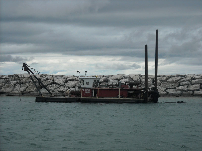
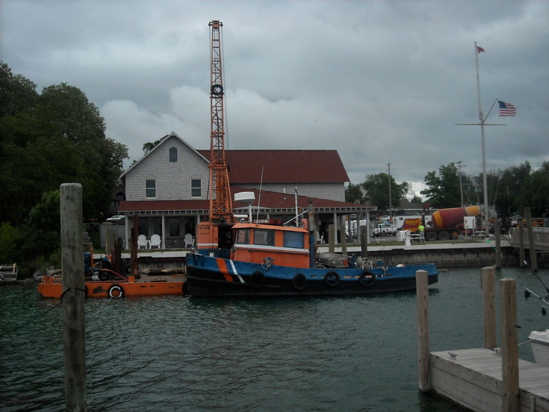
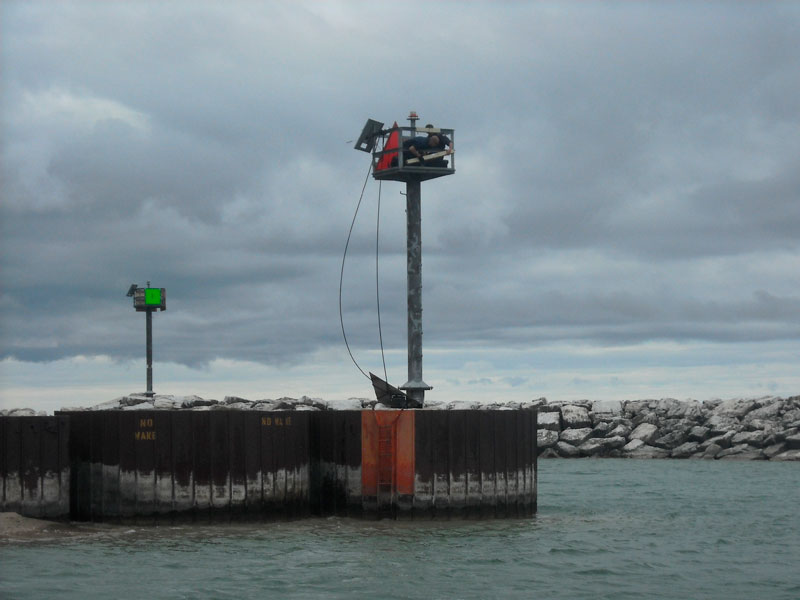
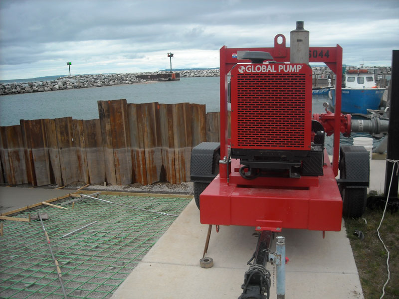
When we got to Leland, as the pictures show above, there was no lack of entertainment from all the construction activity. The dredging project had just been finished the day before, and the suction dredge was laying in the harbor made fast to the bottom with its spuds. The entrance channel had been cleared and deepened to 12-foot depth at the current water level. The Coasties were working on replacing or repairing the big day marks and the lamps on the harbor entrance aids to navigation. A barge and tug were moored to the docks along the shore where they were working on setting new pilings as part of making the docks comply with the Americans with Disabilities Act. The harbor will have four slips that will provide access for boaters with disabilities. The old boat launch ramp has been completely removed, and a coffer dam put in place. A very large pump that ran continuously all day and night kept Lake Michigan out of the ramp area. A gang of construction workers were engaged in pouring 45-cubic-yards of cement for one-half of the new ramp. A fleet of cement trucks pulled into the area to transfer their concrete to the big aerial pump that lifted mixture overhead to the ramp area. It was quite an operation to watch. By evening all the activity was done, except for the drone of the dewatering pump for the coffer dam. The harbormaster had wisely given us a slip that was as far away from that pump as possible, so its noise was not a disturbance for us when we retired to sleep that evening. The construction crew for the dredge and a second crew for the pile driver got started very early the next morning, and we were awake at 6:30 a.m. as a result of their noise making. |
| newt |
posted 06-24-2012 08:47 PM ET (US)
"The ramp is to be 8-inch thick concrete with #6 steel re-bar on 12-inch centers set E/W (unclear)..." In this case "E/W" means "each way". |
| jimh |
posted 06-24-2012 09:11 PM ET (US)
ROGER on E/W = each way Thank you. |
| newt |
posted 06-24-2012 09:11 PM ET (US)
Interesting write up and thumbs up for including the construction progress photos. The facilities in that harbor look to be very nice. |
| jimh |
posted 06-25-2012 09:59 AM ET (US)
Yes, Leland is a wonderful harbor. The marina facilities are top notch. The boater's lounge there is on par with a yacht club. The shower and bath house facilities are all new and very nice. Those upgrades were made over two years ago in what is called "phase one" of a general upgrade to the facilities at Leland. The ramp was originally constructed in the 1960's when, as the harbormaster remarked to me, the biggest trailerable boat was about a 17-footer. The new ramp should be able to handle the largest of trailerable boats. This new ramp will permit two boats to use the ramp at once. The old ramp was a single lane. The ramp, the new docks for disabled boaters, new public rest room facilities, and a general revision of the parking lot with new pavement, new lighting, new landscaping, and so on, are all part of "phase two" of the overall upgrade of the facilities at Leland. The cost of phase two of the project is about $1,100,000. Most of the funding for it is coming from a State (of Michigan) Waterways grant in a 75/25 shared cost program. The little town of Leland, however, recently borrowed $940,00 as a bridge loan so it could pay the contractors in a timely manner to keep the project moving along without further delays while it waits for the state money to be provided in reimbursement. Even with all the improvements, the new parking lot at Leland will only accommodate about 18 boat trailers for parking. There are some arrangements possible for over-flow parking at other local facilities. As I recall, the last time I left my trailer at Leland we parked it in a church's parking lot, as we were there mid-week or at least after services on Sunday. By the way, the local Salmon fishing this Spring has been fantastic, according to reports from anglers trolling a few miles offshore from Leland, and having the ramp out of commission for several weeks has no doubt been an impediment for local trailer boats to get out to those waters. |
| jimh |
posted 06-25-2012 10:09 AM ET (US)
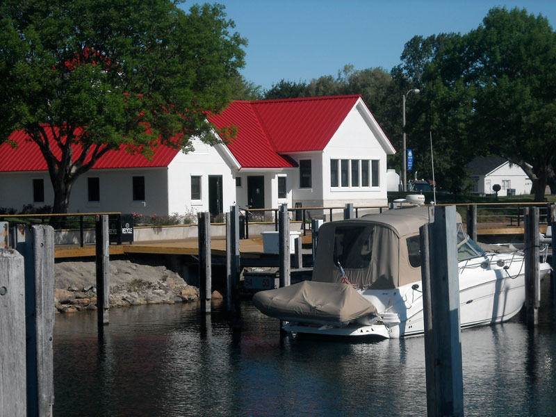
I should also draw attention to the completely new facilities at Northport. Over the Winter and Spring the town of Northport has completely renovated their harbor's bath facilites. The new showers and wash rooms are wonderful. They have also added a boater's lounge facility, as well as a very nice washer and dryer for doing laundry. The new bath house follows the style of the new dock office building, featuring a bright red metal roof. There are also upgrades to the general area, including a new boardwalk promenade, new public rest rooms, and improved swimming beach facilities. The boat ramp was already a two-lane deep ramp, so no improvement was needed there.
|
| jimh |
posted 12-05-2013 01:19 PM ET (US)
To follow up on my report about the reconstruction of the boat launch ramp at Leland, I can note that we returned to Leland in 2013 to find the ramp finished and in operation, with one variance from the plans. The rubber gates intended to be installed at the end of the concrete ramp for prevention of erosion of the down-sloping gravel to the lakebed--called prop wash deflectors--were not in place. I believe that due to low water levels they were either not installed or were removed. The prop wash deflectors were to be 1.5-feet high and the end of the ramp was to be 4.4-feet below water at Low Water Datum. That would suggest that the top of the prop wash deflectors would be 4.4 - 1.5 = 2.9-feet below water at Low Water Datum. From August 2012 to June 2013 the water level on Lake Michigan was below the Low Water Datum, sometimes as much as 1-foot 5-inches below Low Water Datum. This would have put the prop wash deflectors only about 18-inches below the water at the low point of the lake level, which, even for small boats, is not sufficient clearance. I also want to mention the bathroom and toilet facilities at Leland. In the Men's washroom there are four sinks. The sinks have faucets where are controlled by some automatic device. You cannot just turn a knob and get water. To get water you put your hands into the sink bowl, and some device detects your hand, turns on the water, and you can wash. On our return visit in 2103 the facilities were just beginning their second season of use. The automatic sinks worked like this. On sink number one, no water would flow, no matter what you did. You then moved to sink number two. Positioning your hands in the sink caused water to flow. The water was cold, unless someone else had very recently used the sink. If you lifted your hands from the sink, the water promptly shut off. If you lowered your soapy lathered hands into the sink, no water returned. Nothing would get the water to flow. You then moved to sink number three. Presenting your hands in this sink, and being careful to keep them fully lowered into the sink bowl at all times, water would flow--and now lukewarm water--and you could rinse your hands. Sink four is held in reserve should you fail to get all the soap off in sink three. You have to love modern technology. |
Powered by: Ultimate Bulletin Board, Freeware Version 2000
Purchase our Licensed Version- which adds many more features!
© Infopop Corporation (formerly Madrona Park, Inc.), 1998 - 2000.