search | FAQ |
profile | register | author help
|
|
|
| Author | Topic: Lake Superior: 2014 Slate Islands |
| Hoosier |
 posted 09-24-2014 10:01 AM ET (US)
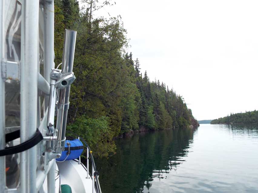
 The Slate Islands The Top of Superior by David Hart Kathy and I have both wanted to go to the "Top of Superior " since the first time we read Bonnie Dahl's "Superior Way". That book is the definitive guide to cruising Lake Superior, written by a cruiser, not by a boating club or magazine publisher. This year we finally got our ducks in a row--or so we thought--and decided to do it. It's a 320-mile drive from our "cabin in the woods" in Michigan's upper peninsula to Terrace Bay, Ontario, the point of departure for the Slate Islands. I'll say this right up front, driving the Trans-Canada Highway from the Soo to Terrace Bay with a 7,500-lbs tow is not for the faint of heart. We crossed the border at the Soo around 10 a.m. and were in the water at the ramp in the Aquasabon River by 6:30 p.m. The Slate Islands were formed by a meteor impact a billion or so years ago and have quite dramatic geology. The coves are deep and the rock walls are nearly vertical. At first look they seem to be just like anywhere else in the North, but they're not. The Slates are different.
The Slate Islands are nine miles offshore and were were there by 7 p.m., scouting for someplace to overnight in Lambton Cove. This was when we realized that we'd forgotten to pack Bonnie's "Superior Way"--the first of our ducks that left the row. We "winged it" and found a nice rock wall that had a tree sticking out of it that we could tie onto. The cove is too deep to set an anchor, and without Bonnie's book we didn't know about the secret spot hidden on the other side from where we were. We settled in for the night; it'd been a long day.
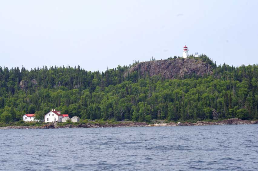
The next day we set out to explore the interior bays and coves. The Slates are actually quite small and we were able to cover all of Lawrence Bay, McGreevy Harbour, and Fisherman's Bay by the early afternoon. We were just putting along so I decided to run on one engine. About 2:30 p.m. we decided to go outside and make the run down the east side of the islands to Sunday Harbour where the Patterson Island Light is. We were lucky; we only had about a residual one-foot swell running from the southeast and no wind. Remember we were facing the full fetch of Lake Superior; the nearest shore to the south was Michigan. It only took an hour to get to the south end and enter Sunday Harbour. We found the lighthouse keeper's dock and tied up to it.
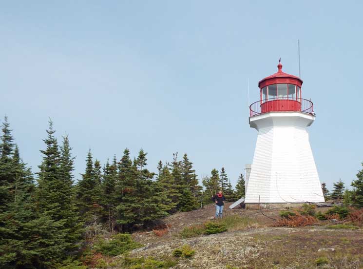
We were met by the former lighthouse keeper's daughter. The Canadian Government had given the family rights to use the old residence after the light was automated, and they were there for the weekend. She gave us directions to the trail up to the light and off we went, to the highest light on the Great Lakes.
We had a nice visit with the lady and took our leave since her husband would be getting back from fishing and would need the dock. We headed west to Horace Cove, which I remembered had a deep sheltered hide-hole at its north end. Once we got there we discovered that it was sheltered from all directions but was only three feet deep. Oh, well. That's when I re-learned why everyone up north either has a plow or claw anchor. My two Danforth-style anchors wouldn't bite. Fortunately it was dead calm, and we just sat there all night. Eventually the anchor rode wrapped around a rock, and we were as secure as we could have been. The next morning we headed up the west side of the islands. Now the weather was starting to deteriorate and a stiff southwest wind was kicking up. We re-entered the main channel between Mortimer Island and Patterson Island at just about Noon, and then went into putting-along mode. This time I shut down the other engine to balance the hours. We spent the afternoon going in and out of little gunk holes thinking about what we'd do if we came back. For sure we'd have an Ontario fishing license--the place is loaded with big fish. Around 5 p.m. we decided to see if we could use the one facility in the islands, the "Come-n-Rest" cabin and dock.
This is an interesting camp. It has a main cabin that has the cooking facility and a couple of bunk beds in it. There is also a separate bunkhouse and an outhouse. When we were there it was being use by a geology field team from Berkeley. They just left all their stuff in the cabin with a note saying they would be back in a couple of days and to please leave it alone.
That night the southwest wind really kicked up. The camp is right on the southwest corner of McColl Island and is exposed to the fetch from the full length of Lawrence Bay. The weather was so bad we decided to use the camp and cooked ashore. The floating dock is not well anchored and was moving four feet side-to-side. I ended up tying the boat to a tree ashore and then tying the end of the dock to another tree. We made it through the night sleeping aboard, and once the wind died down the dock reset itself. The next morning we were heading home. There are some things that we are taught in Power Squadron boating courses that most of us smart asses say, "it'd never happen to me". Yeah, right. Like, always study the electrical system in your new boat. Well, as I said, we were putting around and I decided to turn off one engine to save fuel. That was okay the first day, when it was my port engine that charged the battery that only ran the rear bilge pump. It wasn't okay the second day, when I shut down the starboard engine and ran most of the day with all the electronics ON. It's the engine that charges the house battery. The next morning when we were ready to leave for the mainland and I went to start the starboard engine all I got was cough, cough, gag, sputter--another duck had left the row. "Okay," I thought, "let's try the emergency parallel switch." Cough, cough, gag, sputter. But the good news was the port engine did start and was running, it just couldn't make enough current to start the starboard engine. (Later it was found a loose connection at a battery terminal was to blame.) We were only nine miles from the mainland and could make it easily on one engine in about an hour. We got ready to leave the dock. As I was checking the two chart plotters, they both went DARK: the house battery had gone below the cutoff threshold for the electronics and they'd shut down--the ducks are no longer in any sort of row! Now this is not funny anymore. The morning fog had visibility at about a mile, and, while I know I could find the mainland, it's finding the thirty-yard-wide mouth of the Aquasabon River that had me worried. Hmmm, Boating 101, always have a back-up GPS. I had a 2006-vintage handheld GPS in my briefcase, "just in case”. I had used that unit as my sole chart plotter on my first North Channel cruise back in 2008. Kathy got it out and the batteries had half a charge in them. Because of my foresight, and careful preplanning--if you believe that--it was compatible with the chart plotters on the boat. I took the Great Lakes chart chip out, put it into the handheld unit and searched for the river mouth. Once I found it, I told it, "Go to Curser" an we were on our way.
An hour and a half later the boat was on its trailer and we were headed back south on the Trans-Canada. The drive south wasn't any more relaxing than the drive north. Photographs by David and Kathy Hart |
| jimh |
posted 09-24-2014 10:38 AM ET (US)
Great narrative and excellent photography. Thank you for contributing it. I think the Slate Islands are officially a provincial park in Ontario. Did you have to obtain a permit or pay a fee to go there? Is recreational fishing permitted there? It looks like you better bring everything you need with you--not much support available on shore. |
| Hoosier |
posted 09-24-2014 11:38 AM ET (US)
Thanks for gently editing my prose. The Slate Islands are a barely developed provincial park. The tip of Patterson Island where the lighthouse complex is located is still Crown Land, which is why the old "village" is allowed to be used by the families of the former light keepers. We didn't need permits because we were not camping ashore. The Slate Islands are a very popular fishing area with the local people. Being only nine miles from Terrace Bay, they are a day trip for local anglers. |
| K Albus |
posted 09-24-2014 12:13 PM ET (US)
Nice report, David. Thanks for sharing the intelligence you were able to gather. I wonder why a "retired" guy would take a briefcase on vacation. Were you able to clandestinely view or photograph any caribou while you were there? |
| Hoosier |
posted 09-24-2014 04:50 PM ET (US)
Women have purses, guys have briefcases. The one caribou we saw in Lambton Cove ran back into the woods before I could get my camera. |
| Teak Oil |
posted 09-24-2014 08:25 PM ET (US)
Looks like fun, Dave. Sam and I need to add the Slate Islands to our list of places to visit. |
| jimh |
posted 09-25-2014 09:52 AM ET (US)
Give us some details of the marina or boat launching facilities at Terrace Bay. Also, it looks like the inlet to Terrace Bay from Lake Superior might be subject to some sand bars and shifting shoals. Is there a marked channel? |
| Hoosier |
posted 09-25-2014 10:33 AM ET (US)
The launch facilities at Terrace Bay are nice. The ramp has a double slope so it's easy to back the truck into the water on the gentle part and have the trailer drop off making launching easy. There are four convenience docks for staging, but the ramp can get quite busy since it's the only one within 20 miles in either direction. There's not much parking but the municipal golf course is a short walk up the access road and there is lots of parking there. Note: the river has an Ontario Hydro plant on it and is subject to sudden changes in flow. There is, I believe, a warning system in place to alert people of flow changes. The river mouth is marked with a lighted daymark. The river itself has some "dynamic" markers, placed based on conditions at the time. Eyeball navigation is the rule. |
| jimh |
posted 09-25-2014 11:49 AM ET (US)
On MARINAS.COM you can see some aerial views of the river, boat launch, and approach to Terrace Bay. See http://marinas.com/view/marina/8149_Terrace_Bay_Marina_ON_Canada I don't see any facilities other than the ramp. I guess you better buy fuel on the highway. |
| Hoosier |
posted 09-25-2014 09:36 PM ET (US)
Yup. Just up the road there is a small, but well equipped, community, that can provide all needed services. There are motels, restaurants, stores, and gas stations, so you can leave stocking up to when you get there. And the Marinas pics don't tell the whole story, the lagoon where the ramp and dock are located look very tranquil, but the Hydro Plant can change than in an instant. In a discussion with the mayor of Terrace Bay, he mentioned that the town was looking at an alternate location for a launch facility because of the uncertainty caused by the Hydro Plant. |
| jimh |
posted 09-25-2014 10:25 PM ET (US)
In 2006 we were traveling the Ottawa River, and we stayed just below the Otto Holden Dam, at a marina in Mattawa. There was a daily water level variation in the river there of about three feet (and sometimes more), caused by the release of water from the dam for hydro-electric power generation. The release of water is usually in the late afternoon. At Terrace Bay the river seems to come down a narrow chute, and I can imagine a big increase in flow from water released at the dam could stir things up. |
| jimh |
posted 09-26-2014 09:31 AM ET (US)
The history of the Aquasabon River and the town of Terrace Bay is more interesting than one might suspect. Surprisingly, the drainage basin of Lake Superior historically only extended a very short distance inland at this point, and a major local river, the Kenogami River, flowed north all the way to James Bay. A water diversion project begun in the 1930's constructed two dams. The Kenogami Control Dam impounded the Kenogami River, raising its level until it was high enough to flow over the edge of the natural boundary of the Great Lakes Basin and change direction to the South, toward Lake Superior. The newly diverted flow and the Long Lake Control Dam created a new lake, Long Lake (Long Lac). The outflow of the Long Lake Control Dam (and the hydroelectric dam at Terrace Bay, built much later in c.1948) greatly increased the volume of flow of the small Aquasabon River into Lake Superior. According to the International Joint Commission (for the Great Lakes) this diversion, in combination with a similar one made about a decade later at Nipigon, has raised the level of Lake Superior by 2.4-inches. These inflow diversions have been greater than the outflow diversion of the Chicago River and elsewhere, and, although not really planned for that effect, have more than offset for the loss of water in all those outflow diversions. (See "The Great Lakes Water Wars," by Peter Annin, page 113.) The construction of the Kenogami Control Dam and the Long Lake Control Dam was completed in 1939, just prior to the entrance of Canada into World War II. The additional water flow in Lake Superior accumulated as the water flowed downstream, with the result that at Niagara Falls it added to the electrical generating capacity there, just in time for the war effort. Locally, the dams created power and water flow for harvesting the forest, and a huge pulp mill was built at the new town of Terrace Bay. In today's more ecologically aware world, we probably will never see another water diversion project of this magnitude on the Great Lakes.
|
| jimh |
posted 10-10-2014 07:59 PM ET (US)
David: I am really glad you: --took this trip, --wrote about this trip, and --published your narrative here. It is a very interesting trip, to an out-of-the-way place, and the narrative is very well written and beautifully illustrated with excellent photographs. Thank you. |
| Hoosier |
posted 10-11-2014 09:17 AM ET (US)
You're welcome. The article you wrote about the river diversions is fascinating. Next year I hope to cruise Nipigon Bay, departing from Rossport. |
| EJO |
posted 10-13-2014 12:09 PM ET (US)
Dave--great trip you had. Thanks for us letting it re-live with you. |
Powered by: Ultimate Bulletin Board, Freeware Version 2000
Purchase our Licensed Version- which adds many more features!
© Infopop Corporation (formerly Madrona Park, Inc.), 1998 - 2000.