search | FAQ |
profile | register | author help
|
|
|
| Author | Topic: Lowrance GPX Export |
| jimh |
 posted 10-09-2011 12:31 AM ET (US)
 On a Lowrance HDS-8 running the latest v4.0-software, I tried to use the FILES... page to export my Waypoints, Routes, and Trails in the GPX format. I have done this before without any problems, but on this attempt the HDS-8 crashed and rebooted itself during the export process. The export process created a .GPX file, but the file was truncated in the middle of one of the Trails listings being exported. The truncated file was about 6-MB in size. Some of the (older) Trails were rather large, with over 20,000 data points. After I deleted the larger (and older) trails, the export to GPX format succeeded. The exported GPX file that was created by the process completing normally was 5.6-MB in size. Curiously, I was able to export the stored Waypoints, Routes, and Trails without having to prune any of the data before export if I chose the .USR format. In the .USR format the exported file was 2.8-MB in size. The crashing of the operating system on the HDS was quite surprising to me, as other than this event the device has been remarkably stable. I think in one boating season of use I have only seen one other software malfunction which required me to reboot the device. The GPX file export crashed every time I ran it, until I pruned the number of files in the export. |
| jimh |
posted 10-10-2011 09:35 PM ET (US)
I spoke via telephone today with a support specialist in Oklahoma regarding the Lowrance HDS series and the FILES... menu option to EXPORT the data contained in the stored Waypoints, Routes, and Trails on the HDS to a file in the GPX format. I explained my experience as described above. After a few minutes of delay while the support specialist researched the topic, he told me that the export to GPX process would likely be limited to about 10,000 data points in the Trails. Since my Trails contained considerably more data points, this was likely the cause of the failure. As a result, I will have to stop using my HDS as the place to archive my trails. I will begin exporting of trails to files, and then I will transfer the files to a memory card for storage elsewhere. |
| jimh |
posted 10-10-2011 09:37 PM ET (US)
ASIDE: There have been many prior comments posted about the time spent waiting on the telephone when calling Lowrance customer service. On my call today I was connected to a well-informed support specialist immediately after routing my call using the automated answering system at Lowrance. |
| jimh |
posted 02-11-2012 03:27 PM ET (US)
I am following up on this thread, after applying the latest v4.1 software update to my HDS-8. The update says it resolves problems with exporting large .GPX files. I tried exporting my current stored Waypoints, Routes, and Trails file from my HDS-8 to GPX format. Previously any attempt to export to GPX format resulted in a crash. With the new software the export was successful. The size of the exported GPX file was over 10-Megabytes. It appears that Lowrance have resolved any problems with GPX file export. For more information on the update patch for v4.1 see |
| jimh |
posted 02-12-2012 10:59 AM ET (US)
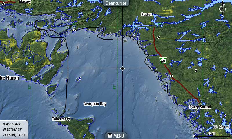
The .GPX format is intended to be a universal format for exchange of navigation data among various devices used with the Global Positioning System (GPS) or what now is more properly referred to by the more generic Global Navigation Satellite System (GNSS) description. To demonstrate the ability of devices to exchange data, I exported the data that recorded the track of my 2011 Cruise of Georgian Bay from my Lowrance HDS-8 in the .GPX format. I then emailed that data to Kevin Albus. Kevin imported the .GPX data into his SIMRAD NSS8 chart plotter, and was able to display it on his screen. Below is a screen capture of the track as seen on Kevin's SIMRAD NSS8. This is a good demonstration of the ability of the .GPX format to permit exchange of data between devices made by different manufacturers.
|
| jimh |
posted 02-12-2012 11:22 AM ET (US)
For more information about the GPX format, visit http://www.topografix.com/gpx.asp TOPOGRAFIX appears to be the originator of the GPX format, or, at least, the source of great deal of official information about the GPX format. See the page of links to further resources on GPX at |
| bluewaterpirate |
posted 02-12-2012 02:43 PM ET (US)
[The Lowrance HDS v4.1 update to fix the GPX export problem, among others,] is a good, solid, update. Simrad already uses the GPX format, so I am able to import or export into Garmin Homeport planning software all my tracks, waypoints, and routes, or I can build new ones and export them back to my Simrad. I can also share my data via my NMEA-2000 network between my Simrad and Garmin. Tom |
Powered by: Ultimate Bulletin Board, Freeware Version 2000
Purchase our Licensed Version- which adds many more features!
© Infopop Corporation (formerly Madrona Park, Inc.), 1998 - 2000.