 ContinuousWave
 Whaler
 Moderated Discussion Areas
ContinuousWave: The Whaler GAM or General Area
Great Lakes Ice
Moderated Discussion Areas
ContinuousWave: The Whaler GAM or General Area
Great Lakes Ice


search | FAQ |
profile | register | author help
|
|
ContinuousWave Whaler Moderated Discussion Areas
ContinuousWave: The Whaler GAM or General Area
Great Lakes Ice
|
| Author | Topic: Great Lakes Ice |
| jimh |
 posted 04-08-2014 09:59 AM ET (US)
posted 04-08-2014 09:59 AM ET (US)  
The Soo Locks opened for the 2014 shipping season on March 25, 2014, but it took about eleven days after that for the first ship to arrive. The CASON J. CALLAWAY had the honor, clearing the locks on April 4, 2014, down bound from Duluth. The CALLAWAY was part of a convoy of three ships and three ice breakers that departed Duluth nine days earlier. The JOHN G. MUNSON also made the trip, but the third commercial ship, the PRESQUE ISLE, had to turn back due to hull damage. Three USCG ice breaking vessels, the 240-foot MACKINAW and two 140-footers, MORRO BAY and KATMAI BAY, accompanied the commercial ships. The MORRO BAY damaged her rudder and had to turn back for repairs, and did not reach the Soo. Once through the Soo Lock, the CALLAWAY took three more days to navigate the St. Marys River to Lake Huron. The 322-foot Canadian ice breaker PIERRE RADISSON joined the fleet to clear ice. The CCGS SAMUEL RISLEY is also breaking ice in the area Ice thickness across most of Lake Superior was reported at 28-inches, but windrows of piled ice were sometimes much higher. The CALLAWAY and MUNSON departed Detour with another USCG ice breaker, BISCAYNE BAY, heading for Lake Michigan. Last report has them at Seul Choix Point, approaching open water in Lake Michigan. The usual time for this voyage would be about 30 hours. This trip has taken about two weeks. A few days ago I heard a USCG officer in command of vessel traffic services at the Soo being interviewed on public radio. He said they may be breaking ice in Lake Superior until June. |
| Teak Oil |
posted 04-08-2014 11:07 AM ET (US)
I saw on the news one of the ice breakers, the Hollyhock, was scheduled to break ice from Gravelly Shoal to the Saginaw River in the Saginaw Bay yesterday, but was diverted to another area. Perhaps they were sent to assist these vessels. I see the mouth of the river is open, I plan to be out there this weekend. |
| jimh |
posted 04-08-2014 12:15 PM ET (US)
The USCGC HOLLYHOCK is is a 225-foot Juniper-class buoy tender, but she can perform ice breaking. The bay-series vessels like the MORROW BAY are 140-foot ice breaking tugs. See |
| jimh |
posted 04-08-2014 01:17 PM ET (US)
Some nice aerial photographs are found at |
| dfmcintyre |
posted 04-08-2014 07:20 PM ET (US)
One of the more interesting sites for recent ice imagery for the whole Great Lake systems can be found here: http://coastwatch.glerl.noaa.gov/webdata/cwops/html/modis/region_map. html
|
| Hoosier |
posted 04-08-2014 08:57 PM ET (US)
When you look at this one that covers Whitefish Bay and the St. Mary's River from the Soo to Detour, it's a wonder anything is moving in the upper lakes. The next question is: How long is it going to take Lake Superior to warm up to "normal" summer temperatures? From the looks of the ice cover she won't warm all the way up and next Fall she'll freeze earlier due to the lower starting water temperatures. |
| jimh |
posted 04-09-2014 12:05 PM ET (US)
It looks like the CALLAWAY and MUNSON made it to Gary, Indiana, where they probably delivered their loads to U.S. Steel. They're both presently in Lake Michigan and heading back to the Soo, according to the AIS data on MARINETRAFFIC.COM. |
| Dave Sutton |
posted 04-09-2014 01:40 PM ET (US)
This is depressing. Jitka and I maintain many permanent moorings in the lakes on a variety of shipwrecks that we dive(as do others) and the ice will have cut off all of the surface buoys. We also put fairly large buoys at 20 to 30 feet so that the main mooring uplines are usually OK, but after this winter even those may be gone. For certain all of the moorings in Whitefish Bay and the Straits of Mackinaw are going to be long gone. It'll be an all-summer work event to retrieve all of them. Dave . |
| MarthaB |
posted 04-10-2014 07:52 PM ET (US)
If you Facebook, Like the Traverse City Air Station FB page. If not on FB, good reason to take up the time wasting obsession. There are some awesome photos posted on their FB page. |
| home Aside |
posted 04-10-2014 09:08 PM ET (US)
Last Sunday it was reported that ice breakers could not enter Marquette Harbor due to six feet of ice, also that area of the U.P reported about 17" of snow fall. |
| swist |
posted 04-11-2014 10:33 AM ET (US)
There were places on the coast of Maine where *saltwater" froze this Winter.** I had not seen that in 40 years of being in the area. Even the offshore temperature was down to 37, which, again, I do not remember ever seeing. ** Even through the freezing temperature of saltwater is only a few degrees below fresh, tidal movement usually keeps it liquid. |
| myakka |
posted 04-12-2014 09:48 PM ET (US)
Not to burst you bubble swist but nearly ten years ago, Provincetown(Ma) harbor was nearly frozen over. I was working for a company that took care of gas piping on a chain that had property on the furthest point(East) of Massachusetts. While driving out to the property I observed the bay full of frozen ice flows jammed into the harbor. This was between 03 and 05. Cant remember the year exactly. |
| Ridge Runner |
posted 04-12-2014 10:51 PM ET (US)
In New York and Raritan Bay the ferry companies had to use tug boats to break-up the ice at the entrance to the terminals. A few harbor seals had been spotted on ice flows in the harbor. |
| saumon |
posted 04-13-2014 11:37 AM ET (US)
Re: satellite imagery One of the most user-friendly and up-to-date satellite imagery site is the Univesity of Wisconsin-Madison Space Science and Engineering Center. With data from the previous day and available for a long history, it come real handy for remote ice watching. http://ge.ssec.wisc.edu/modis-today/index.php When you first select a region, you see it on the 2000m scale. You can then browse through the previous day and/or zoom in to the 1000m or 250m scale for the selected day. That site host the images taken by two satellites, Terra and Aqua and you can also switch which one you want to view, as you can choose to look a the images in true of false color. |
| dfmcintyre |
posted 04-13-2014 02:31 PM ET (US)
That site seems to be using the same imagery as what I posted earlier. Looks like UW is pasting multiple images together and making the website more user friendly... Here's one of the NOAA sites for the region: http://coastwatch.glerl.noaa.gov/webdata/cwops/html/modis/region_map. html I hesitate to say that it's the main site for this type of imagery, as I've found that many of the NOAA sites are somewhat connected; i.e. there are departments within NOAA that are using the same raw data, but "massaging" and producing it for their own disparate user bases. |
| saumon |
posted 04-13-2014 02:33 PM ET (US)
As an example, these days I use it to monitor the lake Champlain, which is a 1 hour drive away, for fishable open water. - On April 6th, it was frozen solid. |
| swist |
posted 04-13-2014 02:41 PM ET (US)
It's actually rarer in ME than farther down the coast because there's so much tidal current. |
| Plotman |
posted 04-14-2014 03:57 PM ET (US)
The Madeline Island ice road finally closed Thursday (April 9th), which is the latest an ice road has ever been open. As far as restarting ferry service, the ferry line's current status is call back in a week. With the weather we have predicted for this coming week, there isn't going to be much melting going on. |
| saumon |
posted 04-14-2014 07:47 PM ET (US)
While on icebreaker ships, I saw a news recently announcing the arrival in Canada of a brand new impressive vessel. The Nanuvik, a 620ft 30 000hp bulk-carrying icebreaker, is said to be the most powerful of this type, being able to sail unescorted in Arctic regions and operate in the extreme winter conditions of the Canadian Arctic. It is capable of maintaining continuous progress of 3 knots in 1.5 m of ice. It will be used to export the concentrates produced at a Nickel mine at Deception Bay in northern Québec and will also supply the mine with equipment and fuel, year round. http://www.newswire.ca/fr/story/1325849/ fednav-brings-new-icebreaker-to-the-canadian-arctic |
| Powergroove803 |
posted 04-16-2014 12:54 PM ET (US)
I had a 1/4" of ice on my boat cover this year, it sucked.... |
| Plotman |
posted 04-24-2014 12:22 PM ET (US)
Madeline Island Ferry finally running! Still ice as far as the eye can see, and the chunks are a good 18 inches thick. April 25 is the latest ferry opening in the 45+ years they have records for - this year is was April 23... https://www.facebook.com/photo.php?fbid=10100234709018052&set=a.567575252492.2108204.1104408&type=1&theater |
| Teak Oil |
posted 04-24-2014 09:09 PM ET (US)
I recently discovered one of my small ponds must have frozen all the way to the bottom this winter: all my fish in that pond are dead. Going to cost me some money to dig it deeper and restock it. At least the bigger 1/2 acre pond with the big fish in it survived. |
| Plotman |
posted 04-28-2014 09:25 AM ET (US)
How fast it goes out when it does. Shots from the sea caves web cam yesterday - timestamps show its just a matter of hours from solid ice to completely open water... https://www.facebook.com/jdccory/media_set?set=a.746022235429483.1073741833.100000651390671&type=1 |
| jimh |
posted 05-12-2014 02:44 PM ET (US)
A story in the May 8th edition of the LEELANAU ENTERPRISE reports the adventure of two men from Battle Creek, described as in their 20's, who on Saturday, May 3, 2014 launched a vessel described as an inflatible raft onto icy-cold Lake Michigan at Sleeping Bear Point, with the intent to paddle 7-miles to the Northeast to the shore of South Manitou Island, where they'd camp. The water temperature of Lake Michigan was said to be 37-degrees. Apparently someone observed this folly and called the local Sheriff. The Sheriff contacted the nearby Glen Lake Fire Department, which has a very nice trailerable response boat, soliciting their assistance in intercepting these two rafters before they got into trouble. Unfortunately, the beach launching ramp at nearby Glen Arbor was not yet in place. The harbor at Leland, a few miles away was still iced in. The nearest open boat ramp was way down in Frankfort. To haul the boat down there on the highway, launch, assemble the crew, and come back 20-miles by water, the fire rescue guys figured would take them six hours. I presume most of that time would be spent making their way slowly across the 20-miles of icy water. Since there was not an emergency declared, Glen Lake Fire decided not to launch. The Sheriff contacted the National Park Service. An NPS Ranger was able to contact the rafters on Saturday night via cellular telephone, and found them safe on the shore of South Manitou Island, having survived the 5-hour 30-minute crossing by paddle boat. Hmm, let's see: seven miles in 5.5-hours, that is a velocity made good of 1.27-MPH. (That's statute miles and statue miles per hour, for you salty-nautical-traditional-maritime-big-ocean sailors.) The story continues with a report that the vessel, still described as just an inflatable raft, deflated overnight. Apparently either the raft needed repair or the rafters did not have an inflation pump, and they declared themselves stranded. To the rafters' good fortune, the National Park Service was planning a visit to South Manitou Island on Monday, coming out from Frankfort, and the young men were given a ride back to the mainland by the NPS. Details of what mode of transportation the NPS used are not provided, but I assume a larger boat. Comments from the NPS folks characterized the two rafters as being unaware "of the hazard of what they were doing." Do you think they were charged for Park Camping fees and transportation? On a related note, the dredging of Leland Harbor, a topic familiar to readers of THE GAM, is being delayed due to ice. The Harbormaster also reports that not "a drop of fuel" as been sold in 2014, whereas normally by this time of year the fuel dock is pumping gasoline and diesel to commercial boats. FOR MORE INFORMATION For some details about the very fine rescue boat at Glen Lake, which could not be employed because of ice and no local boat ramps in operation, see http://www.glenlakefire.com/aboutuspages/appartusspecs/ apparatusfirerescue371.html Also, that boat was financed entirely by local funds, no big federal money being passed around for the little metropolis of Glen Arbor Township. Last Spring and mid-Summer, at least two people died from exposure and hypothermia in Lake Michigan in this area. See my report of those deaths in http://continuouswave.com/ubb/Forum1/HTML/022245.html For the saga of Leland Harbor dredging, see http://continuouswave.com/ubb/Forum1/HTML/021439.html For information of the wonderful new boat launch ramp at Leland, still iced in, see: http://continuouswave.com/ubb/Forum7/HTML/001279.html |
| jimh |
posted 05-14-2014 01:34 PM ET (US)
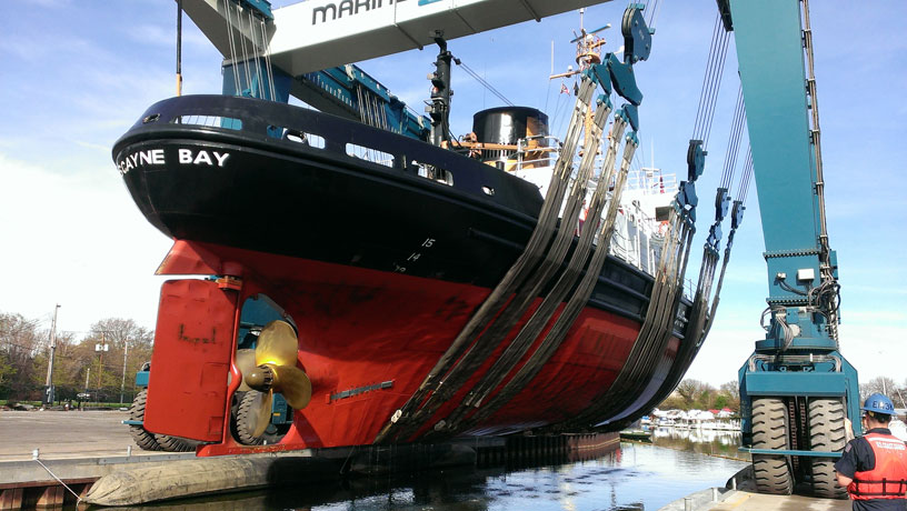
Following up on the initial article in this thread which mentioned the Bay-class United States Coast Guard cutters, e.g. MORRO BAY, KATMAI BAY, BISCAYNE BAY, and several others, I just noticed that the Coast Guard is now hauling these big ice-breaking tugs using a 770-Ton Travel-Lift at Great Lakes Marine in Cleveland, Ohio. These Bay-class ships are enormous steel-hulled ice-breakers. I cannot imagine the strength, rigidity, power, and care necessary to yank them out with a Travel-Lift.
I believe that the Travel-Lift was invented on the Great Lakes, in Sturgeon Bay, Wisconsin. See http://www.marinetravelift.com/about.aspx
|
| Plotman |
posted 05-23-2014 09:48 PM ET (US)
It's not over yet - Great Lakes ice, that is - this is out in front of our house on Madeline. Today. http://i.imgur.com/E9fZdJr.jpg?1 The marina is still empty - for obvious reasons. |
| Jeff |
posted 05-23-2014 10:05 PM ET (US)
Fixed link [Thanks!--jimh] |
| Teak Oil |
posted 05-25-2014 08:53 PM ET (US)
My friend lives in Munising and on Friday Munising Bay was still completely full of broken ice. Lake Superior is going to be chilly this year |
| dfmcintyre |
posted 05-26-2014 06:18 AM ET (US)
A friend mentioned that there's an upside..... free snowcones until September in the UP.... |
| |
Powered by: Ultimate Bulletin Board, Freeware Version 2000
Purchase our Licensed Version- which adds many more features!
© Infopop Corporation (formerly Madrona Park, Inc.), 1998 - 2000.